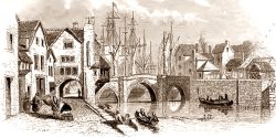
West Street is a lost medieval suburb of Bridgwater.
Within about a century of the founding of the town of Bridgwater in 1200 the borough limits were set using four stone gateways, the North, East, South and West gates the Durleigh Brook and a series of rhines. The growing borough quickly expanded beyond these limits, encompassing Monmouth Street in the eastern side of the town and West and North Streets in the western side.
The Westgate is first recorded in December 1291. This was a substantial structure and was built over in May 1299 by Richard Maidus. Properties are mentioned without this gate not long after although the first that can be exactly dated with any certainty is from April 1307, naming the road ‘without the Westgate towards the West Wayhur’ presumably West Street itself. A wayhure was a pool of water where horses could drink, and this was presumably somewhere along the Durleigh Brook. North Street was known as the ‘without the Westgate towards Kidsbury’ or ‘towards Wembdon’ and is first recorded in December 1317. These streets are first designated recognisably as West Street and North Street in 1335 and 1355 respectively.
Thomas Bruce Dilks extimated that this area of the town in 1445 contained about 19 houses, from the tallage or rate lists.
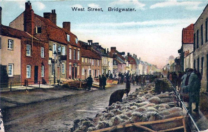
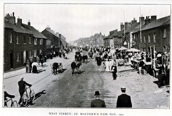
West Street covered the distance between Bridgwater and St. Matthew’s field, which was part of the manor of Bridgwater Castle. This field was named after the town’s fair which commenced each year on St Matthew’s day. This had moved out of the town to these fields by 1404 and is still held every year to this day, although only lasting for four days and not eight. Beyond this were the lucrative and fertile castle lands of Durleigh. West Street was traditionally the location of the town’s sheep fair and you will note in the above picture that the sides of the street were sloped, to aid in the display of the livestock.


The Rev Powell gives this description of West Street on a typical fair day in the nineteenth century: ‘n West Street nearly every other house was licensed for the sale of drink, beer and cider. Instruments of music played all along the streets, both within and without the houses; on the upper floors (wisely propped up with poles as supports) dancing was vigorously indulged in. Blind fiddlers played. Out of windows hung poles, covered with ribbons, little toy ships, pumpkins, vegetable marrows, with other delicacies, indicating that drink might be had within. West Street was an exceedingly busy and noisy place at fair times‘.
There were a set of Almshouses near the Westgate, first mentioned in 1455, which had a small campanile, a bell set onto the roof. These, along with much of the rest of the area outside of the gate were completely levelled during the civil wars in order to provide a clear line of fire for the town’s defences, although no fighting seems to have occurred in this part of town. After the wars the streets were rebuilt. The West Gate itself and surrounding buildings were demolished at the turn of the eighteenth and nineteenth centuries, and further buildings on the corner of North Street and Penel Orlieu, called West Bow corner were demolished in 1901 to further wider the road.
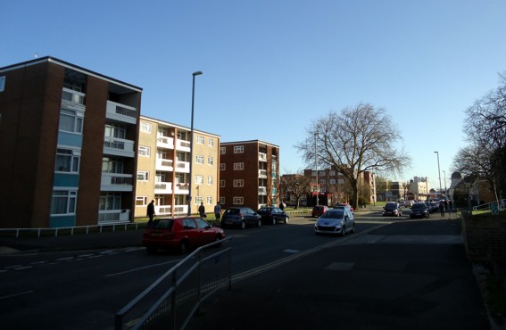
In the eighteenth and nineteenth centuries the area became poorer and various courts were constructed to house poor workers, and these quickly deteriorated into slums, notably along Albert Street. This was partially the reason for the areas complete demolition in the 1960s, but also to make way for the Broadway bypass which was opened in February 1964 after having been extended from the Taunton Road to Penel Orlieu. The medieval property layout was completely destroyed and a whole new planned estate was laid out. The Westfield tower of municipal housing was opened in 1965 and in 1966 Westfield Church was opened at the corner of St. Matthew’s field.
Notes on the Street Names
West Street dates to the foundation of Bridgwater in 1200 and was simply known as ‘without the Westgate’ – the Westgate being the boundary of the town, which stood roughly in the middle of the Broadway junction. The first recorded mentions of occupation outside of the gate occurs within the next century. It is called West Street simply because it carries the main route out of the town heading West. It was first called this in c.1335.
North Street dates to a similar time, although it was initially known as ‘the Road to Kidsbury’ (by c.1300), Kidsbury being a prosperous settlement that seems to have died out in the fourteenth century, possibly because of the Black Death. As Kidsbury declined and the main route over the marshes changed from Victoria Road to Wembdon Road, it became ‘the road to Wembdon’ (by c.1373). It eventually became North Street (first mentioned in 1355), not because it was the main route out of town heading north – it isn’t – but as a reference to West Street. It adjoins West Street, but faces north, hence North Street. In the Middle Ages ‘North Street’ was usually the name for the north portion of the High Street (at least in the 1260s), which was divided from the south portion (South Street) by a small row of shops, the Shambles, which was removed in the eighteenth century.
Moat Lane marked the edge of the town ditch, which ran to its east. This ditch defended the Westgate. For a time Moat Lane was referred to as Bell Lane, in reference to the adjoining inn. The lane was destroyed to make way for the Broadway. Although this section of the town ditch has not been excavated, part of it was discovered under Mount Street in 1973, revealing it to have been about 16 feet wide.
Albert Street dates to sometime in the thirteenth century, not long after West Street, and was laid out when that street was divided into burgage property plots. The name Albert Street dates to the 1850s, in honour of Prince Albert. Before this it was called Roper’s Lane, although before that in the middle ages it was called Blind Lane (because it terminated in a dead end, presumably before Halswell Lane joined it up to West Street).
Halswell Lane takes its name from the adjoining Halswell Inn, which was presumably part of the large property empire of Halswell House near Goathurst.
St Matthew’s Field (or ‘Fairfield’) takes its name from the medieval fair held there, which was held on St Matthew’s day on 21 September. This particular fair was first mentioned in 1249 and was the second annual fair allowed to the town. It was principally for the sale of sheep and originally held inside the town, probably on the Cornhill. Outgrowing its original home, the fair moved to the Fairfield by 1404 and has been held there ever since.
Property Histories
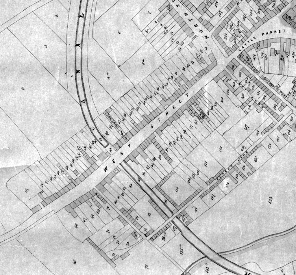
| 7: The North Pole Inn, 23 North Street | 8: 19 and 21 North Street, and Jones’s Buildings | 9: 17 North Street | 10: Grocers, 15 North Street | |
| 11: 11 North Street | 12: 9 North Street | 13: 7 North Street | 14: 3 and 5 North Street. Behind: Southborne Terrace | |
| 15: The Cottage Inn, 1 North Street, also Smithy. | 16: North Street Terrace | 17: No.2 Court/Tilly’s Buildings | ||
| 20: No.4 Court/Paine’s Court | ||||
| 23: No.6 Court/Milton’s Place | 24: No.8 Court/Harris’s Court | |||
| 27: Manchip’s Court | ||||
| 35: Cole’s Buildings | ||||
| 37 Jones’s Court | 38: Fursland’s Court | 40: Waite’s Buildings | ||
| 47: Cook’s Place | ||||
| 53: 110 West Street and Webber’s Buildings | 54: 112 West Street | 55: 114 West Street | ||
| 56: 116 West Street | 57: Claremont House, 118 West Street | 58: 120 West Street | 59: Ivy Green, 122 West Street | |
| 66: Westfield House, 101 West Street | 69: Lewis Court | |||
| 70: | 71: 1-6 St Matthew’s Field and Bryant’s Buildings | 72: 7-8 St Matthew’s Field | ||
| 73: 9 St Matthew’s Field | 74: The Cock Inn, 10 St Matthew’s Field. Also Albert Court. | 75: Nursery, 10 St Matthew’s Field | 76: Coombe’s Buildings | |
| 77: Bulpin’s Place | 79: Gibb’s Court | |||
| 80: The Halswell Inn, 85 West Street | 81: 83 West Street | 82: 81 West Street | ||
| 86: West Street School / Ragged School, 67 West Street | 87: 65 West Street | 88: Nag’s Head Inn, 63 West Street | ||
| 91: West Street Place | ||||
| 99: Long’s Court | 100: Bailey’s Court | 101: Harding’s Court | ||
| 104: Excel Fish Restaurant, 3 West Street, also Carriage Works | 105: The Cardiff Arms, 1 West Street | 106: May’s Buildings | 107: Part of Albert Street Schools | |
| 110: Albert Street Schools/Friarn Primary School, Albert Street. | 111: (corner property) Cottage Inn/Engineers Arms, 14 Albert Street | 116: Bulpin’s Buildings | ||
| 117, Jolly Sailor Beer House | 117a, No.11 Court, Albert Street, or Humber’s Buildings | 118: Manchip’s Buildings | 119: Preece’s Buildings | |
| 120: Cottage Place | 121: Cottage Place | 122: Albert Place | 123: Hutching’s Row | |
| 124: Wesleyan Burial Ground, Albert Street | 125: Society of Friends (Quaker) Burial Ground, Albert Street | 126: No.11 Court, Albert Street or Gloster Place | ||
| 130 Vickery’s Buildings | 136: The Almshouses, West Street | |||
| 201: West Bow Terrace | 533: The Friary Field |
References:
Dilks, Pilgrims in Old Bridgwater (Bridgwater, East Gate Press, 1927)
Dilks, Bridgwater Borough Archives (Somerset Record Society, 1933)
Dunning, Bridgwater History and Guide (Sutton, Stroud, 1992)
Jarman, History of Bridgwater (St.Ives, 1889)
Lawrence & Lawrence, A History of Bridgwater (Phillimore, Chichester, 2005)
Powell, Bridgwater in the Later Days (Bridgwater, 1908)
Squibbs, Squibbs’ History of Bridgwater (Phillimore, Chichester, 1982)
