[DIAGRAM FROM BW ARCH SOC]
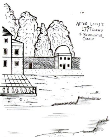
In 1981 Langdon and Richardson excavated a cross section of the northern part of the castle most.. They uncovered its full width, which was around twenty metres from lip to lip. The excavation revealed the moat here had been over half filled in the late seventeenth century. This thinner moat was recorded on Locke’s map. [1] The moat here was used for growing reed which was used for thatching some of the buildings inside the castle. [2] In 1856 what was left of the moat was observed as a ‘large open drain’ by the Somerset Archaeological Society. [3]

Langdon and Richardson did not find traces of a stone wall or any foundation cuts in the natural ground surface. It appears that after the moat was initially cut there was a small wooden fence running along its lip, pottery dating it to no later than the early thirteenth century. A timber framed building was also found contemporary to this, within the fence. Sometime later an earth bank was constructed above these two layers which was not dated, but showed the demolition of the timber building. Above this bank an even larger earthen bank was constructed sometime in the thirteenth century. [4] It is possible that these two mounds represent the location of either a continuation of the stone wall found at the river, or else of a timber section of curtain wall. This area was possibly the outer bailey of the castle and stone may have been initially reserved for the inner.
When the castle was in crown hands in 1246, an order was sent to renew the ‘palisade’ round the castle. [5] As there was a distinction between stone walls and timber palisades at this time, this is a good sign that the castle was part stone (as shown by the river) in its inner sections and wooden in its outer. [6] Highham and Barker have argued extensively that timber castles were not second rate or temporary: Clifford’s tower in York, for example, gives the example of a bailey with timber palisad, which circled a stone tower. Replacement with stone began but was never completed and the palisade remained for a very long time. [7] In 1394 there is mention of a substantial oak palisade being rebuilt to the north of Bridgwater castle. [8] It is possible that the area Langham and Richardson excavated was part of this palisade. The sequence revealed in the excavation might be interpreted in the following way. Initially, while major works were being carried out at the river front, the area here was simply outlined with moat and fence, perhaps ready for King John’s visit in 1204. [9] The second phase may relate to 1222, when the castle was granted fifty oaks, which might correspond to the first bank. [10] The second mound might relate to the order of 1246, mentioned above, being carried out.
[1] Langdon, M. & Richardson, F., ‘Castle Moat, King Square, Bridgwater’ in Bridgwater & District Archaeological Society Report (1981) p.30
[2] Dilks, T. B., ‘Bridgwater Castle and Demesne towards the end of the fourteenth century’ in The Proceedings of the Somerset Archaological and Natural History Society (vol. 86, 1940) p.101
[3] Parker, G., ‘Proceedings of the Congress’ in the Journal of the British Archaeological Association (Vol. 12, 1856) p.376
[4] Langdon & Richardson, ‘Castle Moat’ p.30
[5]Calendar of the Liberate rolls (HMSO, 1916) p.21
[6] Highham, R. & Barker, P., Timber Castles, (Batsford, London, 1992) p.128
[8] Lawrence, J. F. & Lawrence, J. C., A History of Bridgwater, (Phillimore, Chichester, 2005) p. pp.35, 138
[9] Dunning, R., ‘Bridgwater Castle’ and ‘Otterhampton’ in A History of the County of Somerset: Vol. 6 (Victoria County History, London. 1992)
[10] Crump, J., ‘The Itinerary of King John & the Rotuli Litterarum Patentium’ at < http://neolography.com/timelines/JohnItinerary.html> [Accessed 25th January 2011]
[11] Greswell, W. H., ‘Bridgwater Castle’ in The Ancient Borough of Bridgwater, Powell, A. H. ed, (Page & Son, Bridgwater, 1907) p.47
