Dated the nineteenth year of the reign of George III (1779), Parliament passed ‘An Act for erecting a Market House, and regulating the Markets, within the Borough of Bridgewater, in the County of Somerset; and for paving, cleansing, lighting, an watching the Streets, Lanes, and other publick Passages and Places within the said Borough’. The schedule attached to this Act lists a number of properties that would be purchased by the new Market House Trustees. One set of seven were purchased as the intended site of the new market house; one set of three were purchased explicitly for street-widening; and the largest, a set of fifteen are a bit more ambiguous. This set of fifteen bounded the part of the south and all the eastern side of St Mary’s Churchyard. The intention was presumably to demolish them and widen St Mary Street, although this does not seem to have happened immediately.
The market house, completed by 1791 in brick, forms the inside part of the iconic 1826 stone market house, the centrepiece of the town. The original house only formed part of the site, while four houses fronted the Cornhill itself, shown on the 1810s Town Plan, one of which was depicted by John Chubb. The seven properties demolished for its creation are not described in any helpful detail, presumably the four survivors of the 1791 phase shown in 1810 were not among these seven. The four dimensions given for the new market house in the schedule are a puzzle: 110 feet west side, 98 feet northside, 92 feet east side and 89 feet south side. The north and east dimensions might roughly correspond to the join between the earlier phase of the market house and the later phase represented by the dome. The bizarre lengths of the south and west sides are more confusing. The difference between north and south sides might be explained if the surveyor had made a mistake by including the length of the Bow Lane (part of St Mary Street) that cut through to the High Street on the north side but not the south. The 20 additional feet of the west side is odd, and presumably part of the complex of buildings extended out into the road.
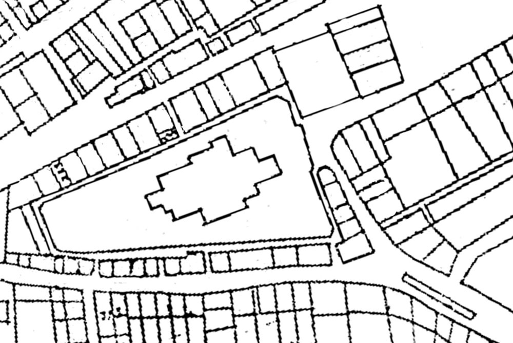

The three properties earmarked for road widening were the old High Cross on the Cornhill; a surprisingly large house in the occupation of Benjamin Bond (42ft wide by 56 feet deep), the location of which is a mystery; and the Cheese Market, which ran the length of a large part of St Mary Street, being 11 feet wide and 94 feet long. The latter survived long enough to be depicted on the 1810s Town Plan, which suggests it started at about 94 St Mary Street, and is overlain on the 1887 OS Town Plan here.
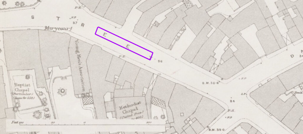
The fifteen properties bounding St Mary’s churchyard are described in greater detail. They are listed running from (but not including) a Dwelling-house in the occupation of Ann and Eizabeth Atey, and Nicolas Evans, to ‘the south east Gate’ of St Mary’s churchyard, then all the way up to the High Street and an public house call the Three Saddles.
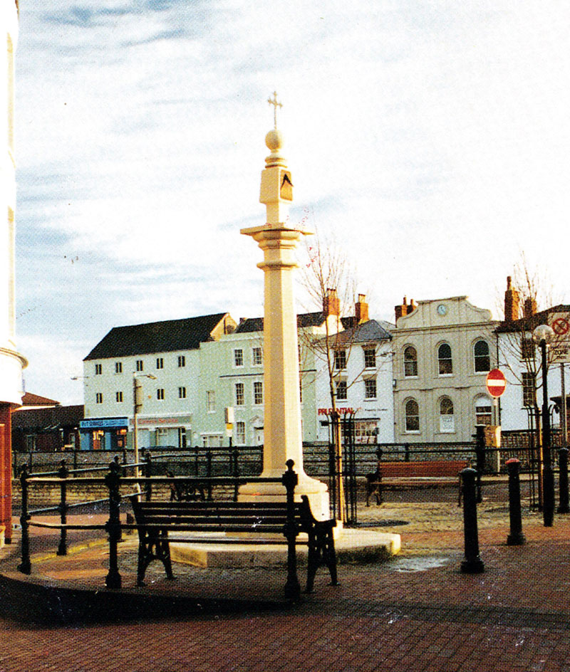
These buildings are shown in vague detail on Strachey’s 1735 plan of Bridgwater, which at least shows the south east passage way to the churchyard. It also shows St Mary’s Cross, which was later moved to Pig Cross, and a modern replica of this cross now stands by the town bridge. This also shows the east passageway to the church, although not in a location suggested by the 1779 Schedule. This map is notoriously imprecise.
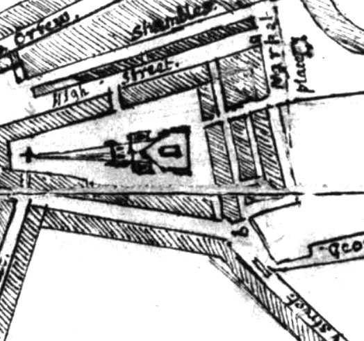
Some of the buildings are shown on the 1810s Town Plan. The northern row had been demolished by this point, and the shapes of the surviving buildings do not match the 1779 schedule. Attempting to overlay this map on the precise 1887 OS Town Plan is not possible using fixed points, indicating that this plan should be taken only as a guide, which would explain the discrepancies. Given the thirty years between schedule and plan we would also expect some changes to have happened to the plots as well.
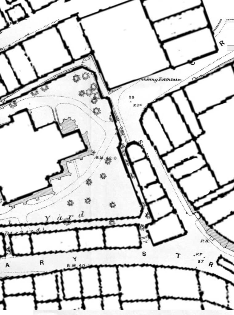
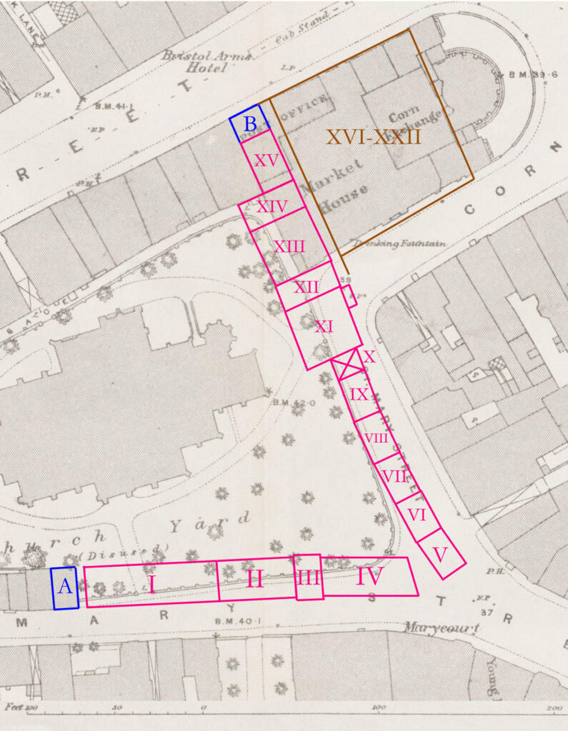
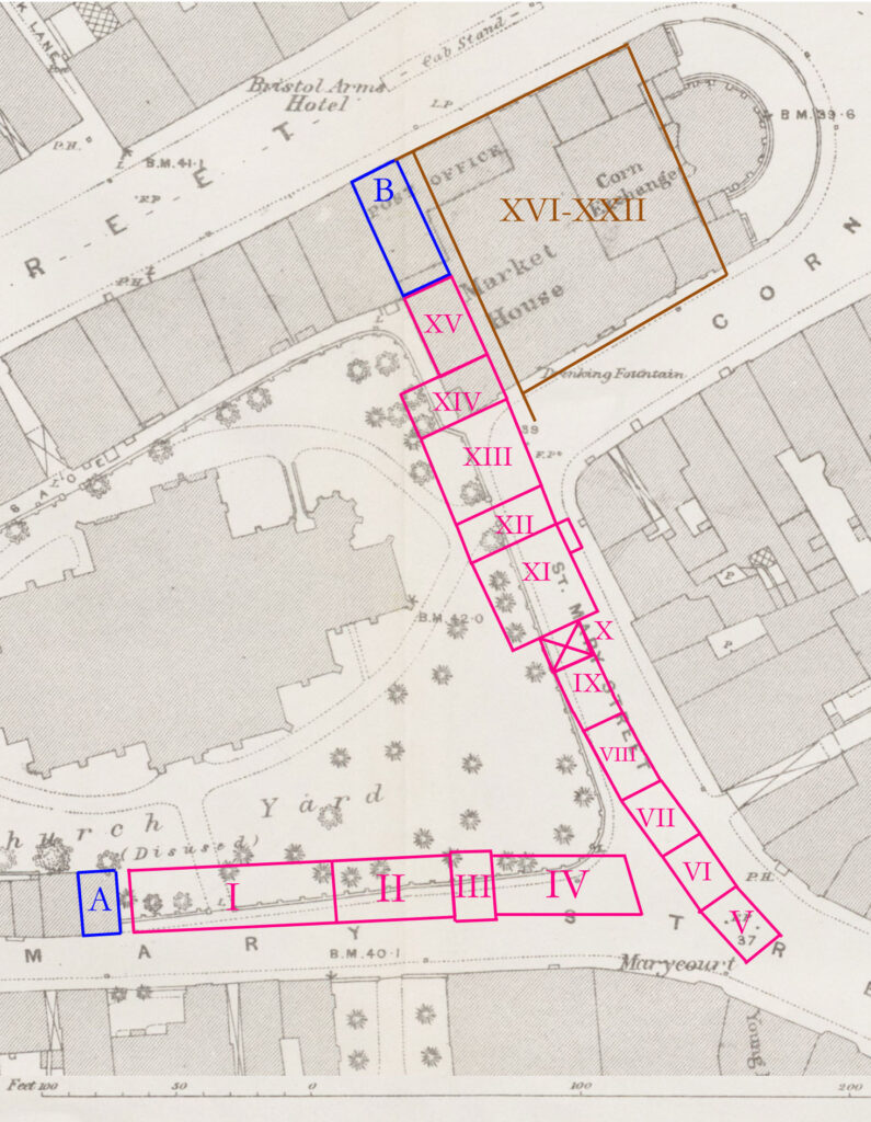
The schedule can be plotted onto the 1887 OS map in two ways. Keeping in mind the sizes of the plots would perhaps be rounded here an there, two interpretations are possible.
The dimensions for the southern row seem to fit neatly against the four surviving properties on the 1887 plan (their survival no doubt being in part their not being purchased by the trustees after 1779). A gap between A and I is suggested from the 1810s plan, although not described in the schedule, but has been added here.
The eastern row is more difficult to pin down, and depends on the size of the Three Saddles (B) on the High Street. If it was a small building, the change in length of properties XIV and XV might be explained by XV being squeezed by the adjoining property in High Street. If the Three Saddles was the same length as the other buildings in the High Street, then the whole row against the church yard then projects further into St Mary Street to the south. This is not impossible, as the row would then nearly join up with the Cheese House, with a little room left for St Mary’s Cross, but the map evidence, albeit flawed, seems to suggest a wider space. Also, the long buildings XI to XIV seem to fit better against the opposite side of St Mary Street in reconstruction 1, especially with the odd projection ‘the Old Post Office’ on property XI. As such, reconstruction 1 might be the more likely of the two.
Exploration of the 1779 Properties
A

I


Documents related to this property appear in the Somerset Heritage Centre D/B/bw/CL/108 (not yet inspected), which describe over the periods 1639 to 1804 ‘Stable and brewhouse, formerly a tenement and garden called Three Halfpenny land, containing a sixteenth of an acre bounded on north by Churchyard. Interested parties Cooper, Mills, Davis, Escott, Clements, Manning.
II

III

IV

V

VI

VII

VIII

IX


X

In the town’s medieval borough archives, frequent mention of the ‘east stile’ to the churchyard are made. It was eventually built over, and the room above the passage way was let to John Champayne up to 1556, when it was demolished (Lawrence History of Bridgwater p.32). It was evidentially rebuilt, as a series of four documents 1670 to 1756 describe this property as ‘a chamber and cockloft over the passage going into east gate of churchyard’ with ‘the street between church and bridge’ (i.e. Fore Street) on east and churchyard on west, with interested parties being a Roger Hoan, a man called Crapp, Thomas Hymons until 1691, then Matthew Luff, then a man called Meyrich (Somerset Heritage Century D/B/bw/CL/109 – documents not yet inspected – Lawrence’s History of Bridgwater p.32).
XI

XII

This appears to be a mostly open plot of land, aside from the outhouse. It is possible, if Reconstruction 1 is accepted, that this property was once part of a roadway, which terminated at the churchyard, a continuation of Fore Street. This would explain the alignment of roads on the 1735 map. More importantly, it would explain the very odd description of a property in the Borough Archives (Somerset Hertiage Centre D/B/bw/CL/96), which described a property (presumably XIII): ‘House with vault under, bounded on south with street from church to Bridge (ie Fore Street), on west with churchyard, on east with lane leading to Little Bow; house newly built between 1672-1676. Interested parties Edwards, Bowring, Bickham, Baily of North Petherton, Tucker, Fisher.
James Wollen is possibly the father of William Wollen, vicar of St Mary’s 1785 to 1844
XIII

Possibly the property described in the notes in XII. This seems even more likely given another document which describes ‘a cellar or vault with court, measuring 36 feet by by 32 feet adjoining with common highway on east and south and churchyard on west; three halfpenny ground on north side of St Mary Street, Endorsed ‘New Part of the Market House’. This was granted to William Bacon of Otterhampton in 1611, along with the property on the other side of Bow Lane and ‘three halfpenny ground’, i.e. property I in this schedule (see above).
XIV

XV

B

Two documents survive relating to the Three Saddles, one of 2 July 1741 (Somerset Heritage Centre DD/BW/2/684) and 5 June 1751 (DD/BW/2/771). These have not yet been inspected.
The Market House

MKP 5 February 2022
