Street and lanes in Bridgwater starting with the latter ‘W’.
Wadham Close: Modern Bower Estate, date TBC. Possibly after either Wadham College, Oxford, where Robert Blake was educated, or the Somerset landed family who sponsored it.
Waite’s Buildings, West Street: Court on the east side of the canal cutting, on the north side of West Street. Shown and named on the 1887 OS 25″ Town Plan – seems to have consisted of six cottages in two joined rows, three facing the street, three facing the plot behind, with a passageway from the street. Five households are listed there in the 1881 census, when it is called Waite’s Folly, at which time there were five households. The very unusual form of this court may be behind this name. It is not clear if this arrangement is shown on the c.1854 Town Plan – a passageway is shown dividing one large building. This may perhaps have been one large dwelling later divided into cottages. Not mentioned in the 1871 census. Still standing at the time of the 1904 OS map, but replaced by the time of the 1930s OS Map. The name presumably refers to the builder or owner, who is not yet identified.
Walnut Drive: Westonzoyland Road Estate, laid out and built between 1967 and 1968 (Town Guide Street Plans). A reference to a tree type, as are several streets in this estate are. Built over a field called Pit Close, possibly due to the presence of a cow pit (TAM).
Walton Close: Modern Bower Estate, date TBC. Name of unknown significance.
Wares Lane: Wembdon. The same Ware as Ware’s Warehouse at the docks, probably Thomas Ware (1818-1902) who lived in the large Oakfield House opposite the lane in the nineteenth century (of which only the stable block now survives, converted into housing). This is a very old trackway between Kidsbury and Wembdon, houses had been built along the northern side by the time of the 1946 RAF photographic survey.
Warren Close: Name of unknown significance. Built over the site of what had been a car dealership in the 1980s, and prior to that the Saltlands Brickworks. This estate was built between 1995/96 (with thanks to Jon White).
Warwick Avenue: Westonzoyland Road Estate, laid out and built between 1961 and 1967 (Town Guide Street Plans). Several of the streets in this estate take their names from British counties. Partially built along the boundary of ‘Cockage’s Orchard’ on its north east side. The rest occupied ‘Kenneil Field’.
Washington Gardens: Built sometime between the 1889 and 1904 OS maps. Mention of building work here is mentioned in the 1898 Borough Sanitary Report. Brassiere factory of Leffman Ltd opened 1939, previously the workshops of T. Stockham, builders (Squibbs). Presumably took its name from Washington Terrace. Built over a field called Cooper’s Four Acres (TAM)
Washington Terrace: The name of the long Victorian terrace in Victoria Road, built sometime between the 1840s and the 1889 OS map, encompassing all the buildings on the west side of the road up to Washington Gardens. Earliest mention found so far is 1881 Ashton and Popham, builders of Washington Terrace and Bath Road were advertising a property to let here (Devon and Somerset News, 2 June 1881). Mention of further building work here is mentioned in the 1898 Borough Sanitary Report. This part of Victoria Road/Malt Shovel Lane was sometimes referred to as Washington Terrace before more houses were built. Supposed to be named after their builder/developer (Ashton or Popham?) although it may have something to do with Washington Lafayette Winterbotham, a noted physician in the town, who worked in the infirmary from 1863 to 1909. The Blake Museum has a collection of insurance documents for No 17: BWRAB : 2014/1/28.
Waterford Close: One of a series of names on a new estate celebrating notable townsfolk. (Exactly Who TBC). Part of the Wills Road ‘Quantock View’ Estate, which was being built from at least 1986 onwards.
Watermans Meadow: Modern NDR development, complete by 2006. Name of unclear significance, possibly another name for the field it was built over, although it is recorded as ‘Four Acres’ on the Tithe Apportionment Map.
Waverley Road: Later addition to the Newton Estate to provide access to the flats built over the site of the old mump in the late 1980s-2000s (dates TBC). Presumably named to evoke waves, Waverley comes from the huge popularity of Walter Scott’s novel, one of the few novel titles to become a widespread placename.
Watson’s Lane: Seems to be part way under construction on the 1971 Town Guide Plan, with the west side complete and east side in progress. Refers to Watson and Company, who owned the shipyard on East Quay for a time.
Wayhure: See Horsepond Lane
Weacombe Road: Part of the Sydenham Estate, under construction in 1953 (BFA: EAW051177) Shown on the 1967 Town Guide Plan. Presumably named after the place in West Somerset.
Webber’s Buildings: See Bussell’s Court
Wellington Road: Presumably named in honour of the Duke of Wellington, or the Somerset Town (fitting with the theme of Polden Street). Initially laid out in 1860: ‘New streets are in the course of formation over eleven acres of ground belonging to Mr Vidal in St John Street, and in the rear of that thoroughfare. One street will run from Polden Street to the railway station yard, and another from the new road to St John Street. These two thoroughfares are being made, and other transverse streets are to be laid out’ Bridgwater Mercury 4 April 1860. We learn elsewhere in that edition of the paper that Mr Vidal was employing the workmen to build the scheme – a Mr Lilly was also involved.
Wellington Place: See Redgate Street
Wembdon Common: Former ‘common land’, ie for the use of the villagers to keep livestock, which runs alongside Church Lane and the Crowpill Rhyne. Now laid out as parkland. The Kidsbury Levels, were also known as ‘the Common’.
Wembdon Hill: The exact meaning of the name ‘Wembdon’ is contested. The latter element is straightforward, ‘don’ usually means ‘hill’ The first element is harder to pin down. That it has an apparently superfluous ‘b’ indicates that there has been a contraction and a squeezing out of an old syllable. In the Domesday Book of 1086 the parish is called ‘Wadmendune’. The Oxford Dictionary of English Placenames suggests this comes from ‘weapmann’ meaning huntsman – so Wembdon thus means ‘Hill of the Huntsman’. Another explanation is put forward by Stephen Robertson in his Somerset Place Names. Wad-men-dune could be the hill (don) of the Wad-men, the men who wade. Wembdon Hill was largely surrounded by marshy land with only small trackways connecting it to Crowpill in the east, Cannington in the west or Bridgwater to the south east, then this name makes perfect sense. Anyone living here necessarily had to do a fair bit of wading through wetland, even if only during the winter. The Hill itself is split into three: Wembdon Hill in the east, Mount Radford at the eastern summit, then Sandford on its western slope.
Wembdon Rise: A modern name applied to the old part of the Wembdon Road within the village of Wembdon itself. Name does not appear on the 1889, 1904 or 1930 OS maps. Date TBC.
*Wembdon Road: A very old route between Bridgwater and Wembdon, which also provides the parish boundary between the two parishes. Unclear when this became the principle route between the two, as there was also a favoured route via Kidsbury, now preserved in footpaths accross the commons. Presumably this route was the easier for carts and early wheeled vehicles. Given the amount of red-Wembdon sandstone used in Bridgwater castle that would have needed carting, this may have popularised this route c.1200.
West Bow Terrace: Victorian Terrace, shown on the c.1854 Town Plan and named on the 1888 OS Town Plan. This terrace was built over a garden plot, shown on the 1810s Town Plan, and the name comes from it’s bow shape. This unusual shape was probably the course of the old Town Ditch, the course of which was fossilised nearby with Moat Lane. The building of the Terrace seems to have resulted in the flattening of this wide shape. ‘West Bow Corner’, at the junction of Penel Orlieu and North Street, was demolished from 19 August 1901. The adjoining terrace was demolished in the 1950s or 1960s to make way for an office block called Westgate House. The name is now remembered in the West Bow retirement home across the road.
West Bower Lane: The road leading to West Bower Farm off of Spaxton Road, once the site of an important Tudor manor house. Bower means ‘Cottage’ in Old English (Ekwall). Just ‘Bower Lane’ on the 1889, 1904 and 1930 OS maps, but presumably changed to avoid confusion with [East] Bower Lane.
Wessex Close: Still open fields in 1953 (BFA: EAW051177) Shown on the 1967 Town Guide Plan. Partially built over Monmouth Villa and its gardens, along with adjoining orchards. The name refers to the kingdom of the West Saxons, which, from the east conquered as far as the River Parrett in 658, expanding further west in 682.
West End: See Penel Orlieu
Westfield: Seven properties mentioned in the 1891 census, after Northfield but before North Street, but formerly in the parish of Durleigh. These seem to be well-to-do villas, and are most likely the properties to the west of Park Road facing St Matthew’s Field. Westfield House stood on the corner of West Street and St Matthews, and is now the site of the church. Named for the West Field, as opposed to North Field.
*West Quay: Usually referred to as the ‘Quay’ in the medieval records of the town. Originally just riverbank, has been built vertically fromt he edge of the riverbed over the centuries. Unclear if it was always a direct route to north of the castle, or how the quay was accessed over the castle moat – a bridge over a weir presumably gave access. Marked ‘Key’ in 1735. Portion beyond the castle moat (now roughly marked by Chandos Street) was called ‘the Butts’ (1735 Stratchey Map), probably referring to a place for archery practice. Became ‘West’ quay sometime after the 1840s when the east side of the river was developed into East Quay. The section beyond Chandos Street heading to Valetta Place was called River Drive in the 1841 census (with thanks to Jill Tretheway).
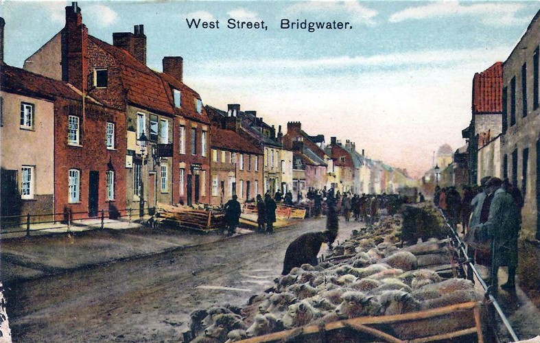
*West Street: A very old road, possibly predating Bridgwater – the name simply means the west-most street of the town. First mentioned on 6 July 1335, relating to a property ‘outside the West Gate of the town in the street called Weststret’ (BBA no.121). Presumably when the town was originally laid out in 1200 the development stopped at the West Gate – by this time however there were clearly a series of tenements. The West Gate itself was first mentioned sometime between the 1260s and 1290s (BBA no.25) and stood in the middle of where the Broadway Junction is now. More on old West Street can be read here.

West Street Place: A court on the south side of West Street. Not mentioned in the 1841 or 1851 censuses, which mention other courts. Shown built by the time of the 1854 Town Plan, so must have been built in the previous three years. Mentioned in the 1871, 1881 and 1891 census. Labelled and shown on the 1887 OS 25″ Town Plan. Renamed Number 7 Court by the time of the 1901 Census. Demolished by the time of the 1930 25″ Map.
Western Way: Modern, built between 2001 and finished by 2006, including a new bridge. Part of the Northern Distributor Road development.
Westfield Close: West Street. c.1965 – TBC. The name Westfield for the 1960s buildings here comes from Westfield House, which stood on the corner of Matthew’s Field and West Street, but in turn took its name from the field it was built on, along with a portion of the rest of old West Street. West Field was akin to North Field, one of the town’s original medieval agricultural fields.
Westminster Way: Modern Little Sydenham Estate, post 2006 – date TBC. Little apparent significance: just a pleasing name to sound grand. Named after the seat of government in London. Built over a field called Lower Blind Yeo (TAM), suggesting that this was the site of a silted up tributary or course of the Parrett – Yeo being a common river name, blind meaning it came to a dead end.
*[Old] Weston Zoyland Road. The Old Westonzoyland Road took the route which is outlined by Salmon Parade, Salmon Lane, then what are now called Colley Lane, Penzoy Avenue, then it seems to have curved up to the course of the current Westonzoyland Road, then tracked behind what is now Dunwear House, past Dunwear Farm, then following the current route. Old Westtonzoyland Road was specifically given to Penzoy Avenue on the 1889 and 1904 OS maps. The name means to road leading to Westonzoyland.
[new] Weston Zoyland Road: laid out circa 1840, connecting the new St John Street to the Old Westonzoyland Road. The railway bridge was built here in c.1873 (MS). The road has been straightened in the mid-twentieth century as there used to be a bend by Dunwear Farm, now the site of St John and St Francis Primary School.
Westover Green: West Street – date TBC. The school is built over Wembdon Road Nursery. The two roads and houses are built over old West Street houses: the main road being built over Cook’s Place court. The name is modern and presumably is a fun riff on medieval Eastover.
Westwood Road: (late 20th c. Bower development – date TBC). Presumably just a woodland reference, as are several streets in this estate are named after tree types. As this was reclaimed marshland there was no wood here in recorded history.
Whiff’s Court: Eastover. Unlocated as yet. Mentioned in a newspaper report int he Taunton Courier for 13 October 1886 (with thanks to Clare Spicer). Not mentioned in either 1881 or 1891 census for either side of Eastover.
White Tail Drive: part of the 2018 Durleigh Gardens Estate, which took its name from species and types of deer (with thanks to Laura Bailey).
Whitebeam Close: (late 20th c. Bower development – date TBC). A reference to a tree type, as are several streets in this estate are. Bower Built over a field called Deacons (TAM).
Whitehall Drive: Modern Little Sydenham Estate, post 2006 – date TBC. Little apparent significance: just a pleasing name to sound grand. Named after the seat of government in London. Built over a field called Lower Blind Yeo (TAM), suggesting that this was the site of a silted up tributary or course of the Parrett – Yeo being a common river name, blind meaning it came to a dead end.
Whites Close: First appears on the 1978 Town Guide Plan. Situated next to the gate to access Wilstock from Rhode lane. One of a series of names on a new estate celebrating notable townsfolk, this one recalls John White, a farmer and butcher, built over his farm land (with thanks to Laura Bailey and Brian Sweeting).
Whitfield Road: Late 20th c. Bower development. South most portion shown, unnamed, on the 1974 Town Guide plan. Name of unknown significance – local worthy?
Wigeon Road: Post 2006 Stockmoor Estate, date TBC. Name of unclear significance. Presumably named after the type of duck.
Wilkins Road: First shown on the 1978 Town Guide Plan. Partially complete by 1975 when Pine Tree Close was added. Presumably named after Hilda Wilkins, landowner here prior to development, who also owned (at least) the site of Pine Tree Close (with thanks to Colin Robert Heath).
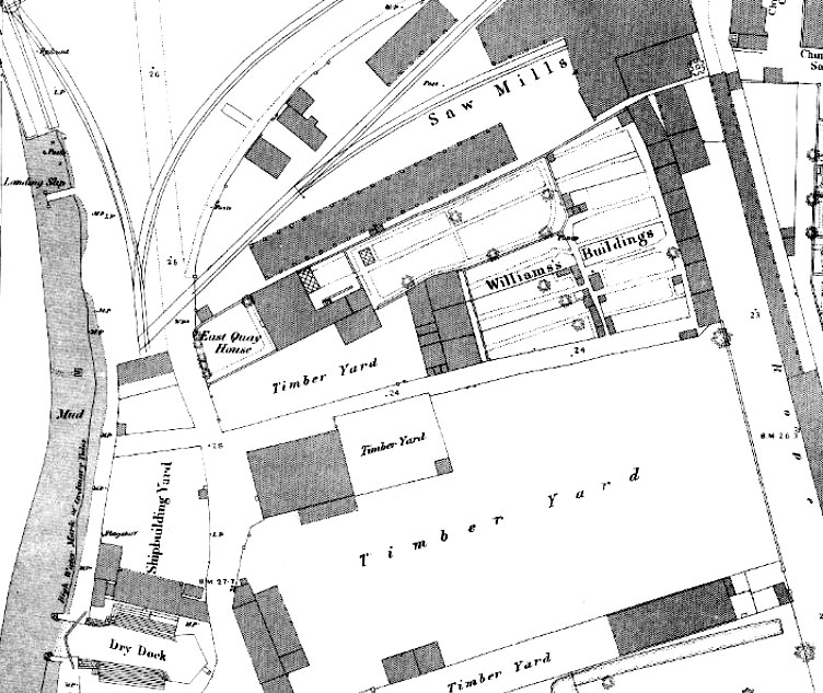
Williams Buildings: a row of cottages between East Quay and Church Street, accessed via a long narrow lane off East Quay named on the 1887 OS 25″ Town Plan. Still standing on the 1946 RAF photographic survey. Demolished about 1957, when proposals to erect a car park over the area were put into action (Taunton Courier and Western Advertiser, 27 July 1957). Probably take their name from Thomas Williams (died 1846), who owned and managed the nearby ship building yard. He presumably built, or at least owned, the cottages to house his workforce. In the 1865 railway submission to parliament, these were owned by Ann Williams, who lived in the adjoining East Quay House (with thanks to Dave Bown).

Williams Buildings: Pricket’s Lane/Market Street – see Blackmore’s Buildings.
Willoughby Road: Built by the time of the 1967 Town Guide plan. Name of unknown significance. Built over fields known as ‘Copse’ (TAM). The first houses here were built as a self-build scheme by 28 families (with thanks to Jeffrey Norman).
Willow Cottages: now only 88 Taunton Road. Appear on the c.1854 Town Plan and are named on the 1889 OS Town Plan. These were part of the plot of the old Hope Inn. The two northern cottages were given a mock-tudor makeover in 1927 to fit with the new Cottage Inn building, and both of these were demolished with the Inn in 2014/5. Now there is a single survivor, number 88.
Willow Brook: Albert Street
Willow Court: (late 20th c. Bower development – date TBC) One of a series of streets in a development, mostly named after trees types and flora. Appropriate in this instance, given how willows were used to line the rhynes in the marshes here.
Willow Walk: Westonzoyland Road Estate, laid out and built between 1961 and 1967 (Town Guide Street Plans). Presumably just a reference to the tree type. Appropriate in this instance, given how willows were used to line the rhynes in the marshes here.
Wills Road: One of a series of names on a new estate celebrating notable townsfolk. Presumably named after Frank Wills, industrialist and Mayor of Bridgwater in 1907. May also refer to Edward Wills, mayor in 1950 and 1951, or Percy Wills, Mayor in 1952 (with thanks to Laura Bailey). The Wills Road is the main artery of the ‘Quantock View’/ Wills Road Estate, which was built by developers Beazer Homes (who also built the Bower Manor Estate). The first show homes were completed by February 1986 (prices set from £28,500 for a two bed home, and £42,750 for a four bedroom detached) and the wider estate was being advertised in 1987 (Bridgwater Journal 30/05/1987; Bridgwater Journal February 8th, 1986; with thanks to Jon White for these references)
Wind Down Close: Part of the cooperative housing estate built by the 1967 Town Guide plan. Names after the place ont he Quantocks, akin to other streets on this estate to be named after local villages. Built over the old Queenswood (TAM)
Windsor Road: (modern development, date TBC) One of a series of roads in a new estate to be named after historic palaces. Built over a field called ‘Southovers’ on the Tithe Apportionment Map.
Winford Terrace: Lower Bath Road. Modern, date TBC. Name of unknown significance.
Witches Walk: Named after the feature running through the Risemoor Marsh, made by the dual channels of the Middlestream Rhyne. Sadly nothing to do with witches or walks: this is a corruption of ‘Weech’s Wall’. The Weech family (often pronounced and even spelt witch) owned land here and built a boundary (Lawrence). The modern street was named in honour of this feature, although at a distance from it. Shown newly built on the 1974 Town Guide plan.
Withygrove Close: (late 20th c. Bower development – date TBC) One of a series of streets in a development, mostly named after trees types and flora. Marshland on the 1840s Tithe Apportionment map.
Wolmer Close: First appears on the 1978 Town Guide Plan in brackets, suggesting it was due to be completed that year. One of a series of names on a new estate (which would eventually become Wills Road, although that came in 1986) celebrating notable townsfolk. (Exactly Who TBC).
Woodbury Road: Part of the Cooperative Housing Estate: appears on the 1955 Town Guide Plan, with its northern portion still under construction. Named in honour of Maurice Woodbury, a Labour councillor and Managing Secretary of the Bridgwater Co-operative Society and later the West Somerset Co-operative Society, which was behind the estate upon which this road was built (Stafford & Pers Comm. Brian Smedley).
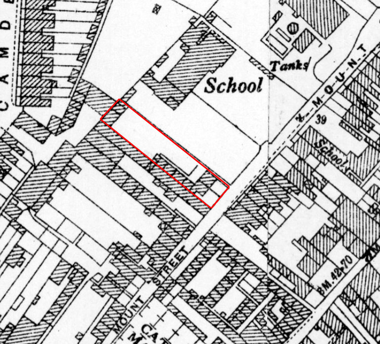
Woodridge’s Buildings: Court in Mount Street. Seem to be partially built on the 1854 Town Plan, more cottages appear on the 1887 OS Map. Mentioned in the 1937 Whitby Light and Lane Directory, consisting of 5 cottages. Mostly seem to be gone by the 1946 RAF photographic survey. Presumably names after the builder/owner.

Wordsworth Avenue: Counterpart to the ‘Coleridge’ street names, as Coleridge and William Wordsworth worked together in Somerset on the Lyrical Ballads, and some of their best-known poems in the late 1790s, although Coleridge had more of an association with Bridgwater. Part of the 1930s Newton Estate, although not shown on the 1930 OS map. First appears on the 1931 Town Guide Plan. Complete by the time of the 1938 Whitby Directory. Built over a field called ‘Walfords’ (TAM).
Wrenmoor Close: Westonzoyland Road Estate, laid out and built between 1967 and 1968 (Town Guide Street Plans). Unknow significance. Built over fields called ‘Montacues’.
Wye Avenue: Westonzoyland Road Estate, not yet built in 1968, but presumably very soon after (Town Guide, 1968). Unknown significance. Presumably just a reference to the river.
Wyldsboro Terrace: Plum Lane Dunwear: mentioned in the 1921 Census. Name of unknown significance.
Wylds Road: (later 20th century – time of Chandos Bridge?) Built over the site of Wyld’s or Wild’s Cement Works (built after 1888, called Spinx Cement Works on the 1904 OS Map), and the older Castle Field Brick Works slightly to its south. The area was called ‘Great Wild Marsh’ on the 1840s Tithe Apportionment Map, south of which is Castlefields.
Wyndham Road: Part of the Sydenham Estate. Shown in the 1939 Town Guide: appears complete on the 1946 RAF aerial photographic survey. The counterpart to Fairfax Road, remembering the commanders of the opposing armies during the Storm of Bridgwater in 1645. Probably a reference to Edmund Wyndham, Royalist governor of the town, who lost the battle.
