This article on Bridgwater’s Ropewalks has been researched and kindly supplied by Clare Spicer and Jill Trethewey. It was made to accompany a number of biographies of several of the ropemaker’s mentioned below, which can be found on the website of the Friends of the Wembdon Road Cemetery.
Bridgwater is a seaport situated on the tidal estuary of the river Parrett, and has been involved in ship building for centuries. The banks of the Parrett have echoed with the sounds of sawing, hammering and the shouts of the ship builders, and filled with the scents of freshly sawn wood, hemp rope and pitch, together with salt water as the tide came in and river mud as the tide went out.
Rope making was an important part of shipbuilding, so where were the ropewalks so vital to Bridgwater shipping, and who was running them?
Street map of 1883, showing the location of known ropewalks around Bridgwater.
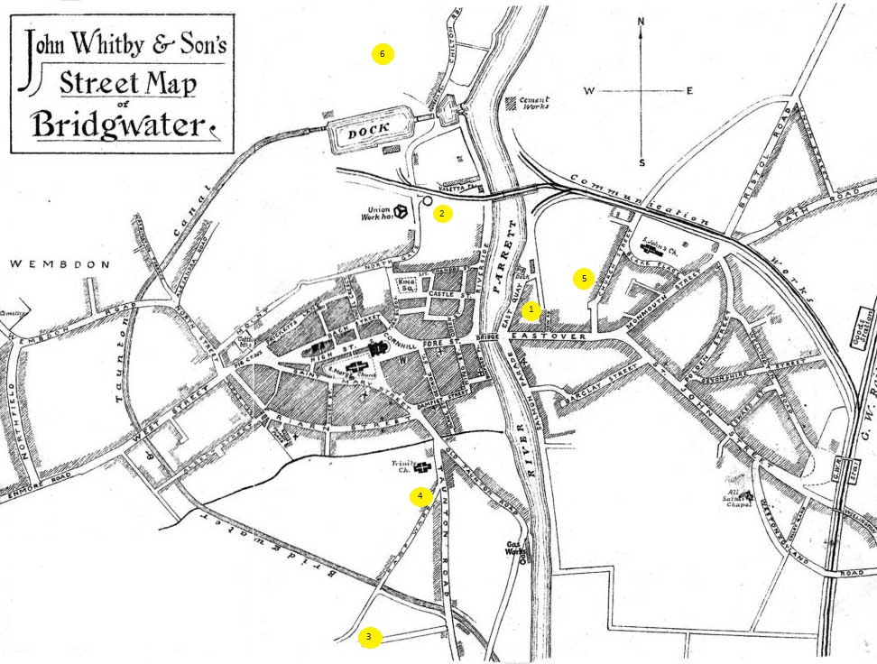
Key to ropewalks on the map above:-
- John Trott family ropewalk on the east bank of the Parrett
- William Edwards’ Northgate/Glass Cone ropewalk
- William Peach’s Hamp ropewalk
- John Waddon’s Hamp ropewalk
- John Waddon’s Eastover ropewalk
- Thomas Parson’s Chilton ropewalk
The list above shows the names of five different rope makers, and six of their ropewalks.
Bridgwater boat and ship builders made vessels of all kinds, from small rowing boats, to large barges, fishing boats and cargo ships. All of these would have needed at least a rope to moor them, and maybe another for an anchor. Many of the larger boats would have one or more sails, and so the industry of shipbuilding encouraged the associated activities of sail and rope making. Sailmakers used a type of twine for stitching canvas together, and for stitching rope edging to sails, so many sailmakers also made twine and rope as part of their business. Some craftsmen specialised in making twine and rope, and these rope makers would need their own ropewalk, a long, narrow path which was used to lay out very long lengths of hemp yarn.
John Trott family ropewalk on the East bank of the Parrett, 1730s or earlier
One of the earliest records for a Bridgwater rope maker was in 1685, when the Bridgwater Receiver’s Accounts recorded a payment of nine shillings to Mr Trott[i]. Bridgwater had suffered greatly during the Siege of Bridgwater in 1645, when most of the buildings in Eastover were destroyed and many people left in deep poverty. The town was still slowly recovering towards the end of the seventeenth century, and in 1685 a group of town merchants got together to pay for a new alms house. John Trott received nine shillings for supplying the ropes for the scaffolding work.
As John Trott was working in Bridgwater during 1685, he may have seen the Duke of Monmouth proclaimed king on the 25th of June at the Cornhill, and he would have certainly been aware of the many executions following the failed rebellion[ii]. John Trott managed to avoid getting into serious trouble, as in 1691 he married Elizabeth and started a family. By 1693, trade in the town had revived sufficiently for an Act of Parliament to be passed, allowing the repair and enlargement of the bridge and quay. John Trott supplied all the necessary rope for the building works. By now he was referred to as ‘Mr John Trott’, indicating that he was one of the established merchants of the town. John Trott senior died at the end of 1729, but his son, also called John, continued his father’s business.
During the 1730s, John Trott (junior) built a graving and repairing dock on the East Bank of the river Parrett. John Strachey’s Plan of 1735 doesn’t show the dock, but does show the end of a rope walk close to Eastover, almost certainly part of the Trott family shipbuilding, sail and rope making business.
The Strachey Plan of 1735, highlighting the start of the ropewalk at the bottom edge of the map
N.B. This map was drawn with west at the top, although has been rotated so north is at the top, for consistency with the other maps shown here. On the original, the rope walk is at the bottom of the map.

This ropewalk was visible on the 1819 Town Plan, stretching from the back gardens of houses on Eastover, behind the roughly rectangular bowling green, and up past the dry dock.
The 1819 Town Plan highlighting the ropewalk running beside the dry dock

This ropewalk lasted until the 1830s. The railway bought the land above and around the dry dock for their purposes, cutting off the northern end of the ropewalk. Then in the 1840s the council ended the trust protecting the Bowling Green and leased the land for development[iii], which truncated the southern end of the ropewalk.
This area has since been changed again, redeveloping the former dry dock and surrounding area where the ropewalk was located.
Modern OS Map showing the area of the former dry dock and associated ropewalk
Rope makers on the 1754 register of electors in Bridgwater
This register listed three rope makers in Bridgwater in the 1750s:-
- John Trott – coal merchant and rope maker
- Samuel Greenfield – rope maker and baker
- John Symes – rope maker
Quite a few of the electors on this register had more than one occupation, some of them surprising combinations. John Trott had the family owned dock and rope walk on the east bank of the Parrett. As a shipbuilder it was not surprising that he also had his own ship for fetching coal from Wales, a trade that most of the Bridgwater registered vessels engaged in.
For Samuel Greenfield to be both a baker and a rope maker suggests that he did not get sufficient income from rope making alone. It is possible that he did not have the investment of a covered rope walk, and rope making was a summer occupation when the weather was dry. Temporary rope walks could be set up in a field, or even along a quiet street. The Symes family were engaged in rope making for more than one generation, but their rope walk has not yet been identified, and they don’t seem to have become wealthy businessmen.
William Edwards’ Northgate/Glass Cone Ropewalk 1793
The 1790 Universal British Directory again lists three rope makers in Bridgwater:-
- Isaac Symes – rope maker
- John Trott – rope maker
- William Edwards – rope maker
William Edwards was recorded as having a rope walk in a lease dated 1793, SW Heritage catalogue number DD/X/BKS/12. “William Edwards, sailmaker to Richard Keen, yeoman, of a plot of waste land some time since used as a lane or footpath now converted into a ropewalk 150 yards long and 4 yards wide with the warehouse or workshop lately erected at the back of the Glasshouse, 1793.”
The Glasshouse referred to in the above description would be the structure more usually called the Glass Cone. Unfortunately the 1819 Town Plan, although it covers this area, does not show any clear detail of a ropewalk. The Town Water Supply Map, c. 1824, does show the area around the Glass Cone, where the ropewalk would have been.
Town Water Supply Map c. 1824, with the Glass Cone labelled.

The dimensions of this ropewalk are known from the lease details. Ropewalks were usually measured in fathoms so this one was 150 yards long, or 75 fathoms (1 fathom = 6 feet).
In the 1832 Electoral Register, Joseph Moule was registered as owning a ropewalk, land and premises, which were occupied by a tenant called John Hobbs, in Northgate. As Northgate is the road which passes the Glass Cone, it is likely that John Hobbs was occupying the Glass Cone ropewalk in the 1830s.
This ropewalk would have been seriously disrupted by the construction of Bridgwater Dock, which began in 1837.
Modern OS Map showing the Glass Cone area.

William Peach’s Hamp Ropewalk 1822
Pigot’s Directory of 1822 lists another three rope makers in Bridgwater:-
- William Peach, rope, sack and sacking – Eastover
- Trevor, Jones, Watson and Co, rope and sailmaking – Eastover
- John Trott , rope and sailmaking – Eastover
The shipbuilder Watson had a changing group of partners, but he worked on the east bank of the Parrett, making rope, twine and sails in addition to building boats. Watson may have been making twine and rope within his boatyard area on the east bank.
William Peach was born in Ilminster in 1785, but had started up a rope, twine and sack making business in Bridgwater by 1822. He had a shop/business office in Eastover, but his ropewalk was located in the Hamp area.
N.B. The lengths of the following ropewalks have been estimated using the National Library of Scotland’s side by side maps and measuring tool. This can only be a very approximate guide.
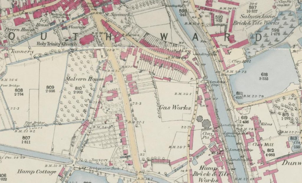
The Tithe Map c.1840 showed that William Peach owned a triangular shaped field in Hamp, and had partitioned the longest edge to make a rope walk.


The tithe map doesn’t show any permanent structures in plot 192, so the ropewalk was probably covered by a long shed. If the grid references are followed through from the tithe map to the 1888 Town Plan, it can be seen that William Peach had sold his triangular field to the brick maker John Browne, who then converted part of it into a pond. The line of the former ropewalk runs along the very edge of the pond, and could have measured approximately 700 feet or 213 metres, but was probably closer to 100 fathoms or less.
William Peach also had other business interests, and he had retired from rope and twine making by 1861.
1888 Town Plan with the former line of William Peach’s ropewalk marked in red

Modern OS map showing the site of William Peach’s former ropewalk

John Waddon’s Hamp Ropewalk 1839
John Waddon was born in Trull, Somerset in 1807, but he was first listed as a rope maker in Bridgwater in 1839. His younger brother Henry worked with him.
Robson’s Directory of 1839 lists three Bridgwater rope makers:-
- William Peach, rope and twine spinner- Eastover
- J Waddon, rope and twine maker – Eastover
- Watson, Luer and Co, ship builders, rope and sail makers – Quay[iv]
John Waddon’s first ropewalk was on a rented field very close to William Peach’s ropewalk in Hamp, they may even have been able to see each other working there. This rented field was a long narrow strip bordered on the west side by a rhyne. Waddon was renting the ropewalk from Richard Symes, but so far no relationship has been found between this Richard Symes and the Symes family of rope makers.
John Waddon’s Hamp ropewalk on the Tithe Map, field 156

Position of John Waddon’s former Hamp ropewalk on the OS Map 1888
This ropewalk could have measured approximately 430 feet, perhaps 70 fathoms long. Again, no building was shown on the Tithe map, so this was probably a long wooden shed.
Line of John Waddon’s former Hamp ropewalk marked in red on the Town Plan 1888

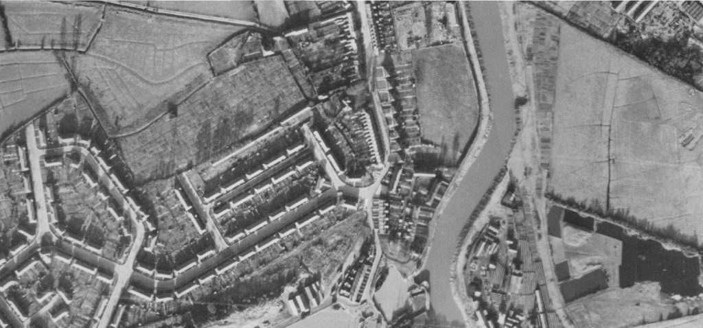
RAF aerial photographs show that the area of the former ropewalk survived as mainly open field until after 1946, but has now been covered by a supermarket carpark.
Modern OS map showing the site of John Waddon’s former Hamp ropewalk

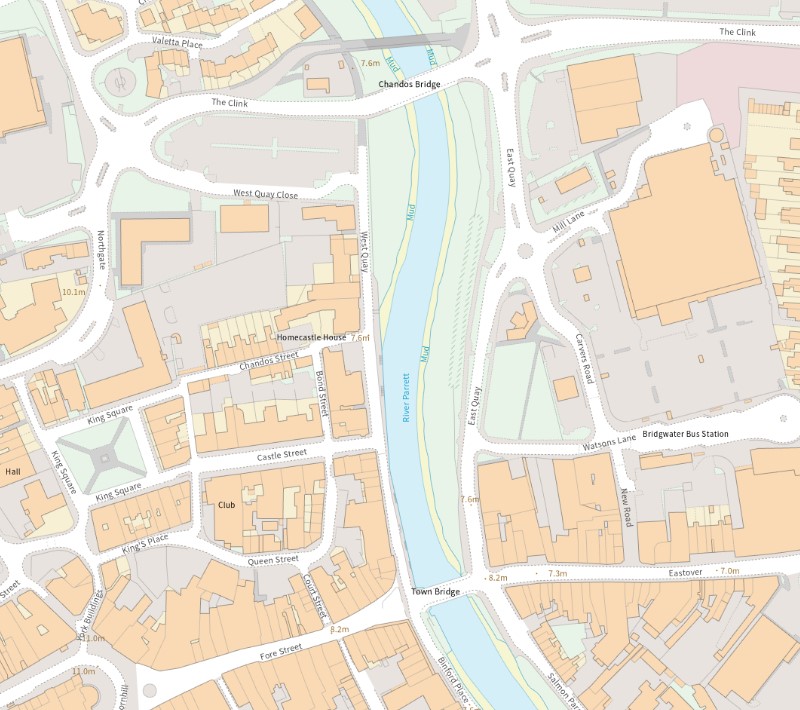
John Waddon’s Eastover Ropewalk 1865
The Post Office Directory of 1866 lists only two rope makers in Bridgwater:-
- Thomas Parsons, rope and twine maker and marine store dealer – Eastover
- John Waddon & Son, rope and sack manufacturers – Eastover
By 1865, John Waddon had been able to establish a permanent, covered ropewalk just off Eastover and behind Church Street, close to his shop and home[v].

The first edition OS map dated 1888, shows that about two thirds of the ropewalk was a permanent, roofed structure, while the end was a shed.
1888 OS map showing John Waddon’s Eastover ropewalk

A close up view of the 1888 Town Plan shows that the end, which was narrower than the brick structure, had columns or posts down one side, while the very end had posts on both sides.
Close up of the 1888 Town Plan, showing the columns down one side of the ropewalk, and posts on both sides at the northernmost end.

In other words, the northern end of the ropewalk was open sided, to let all the dust and rope fibres blow away. The 1865 photograph suggests a brick built structure with brick columns at one side with open gaps between the columns.
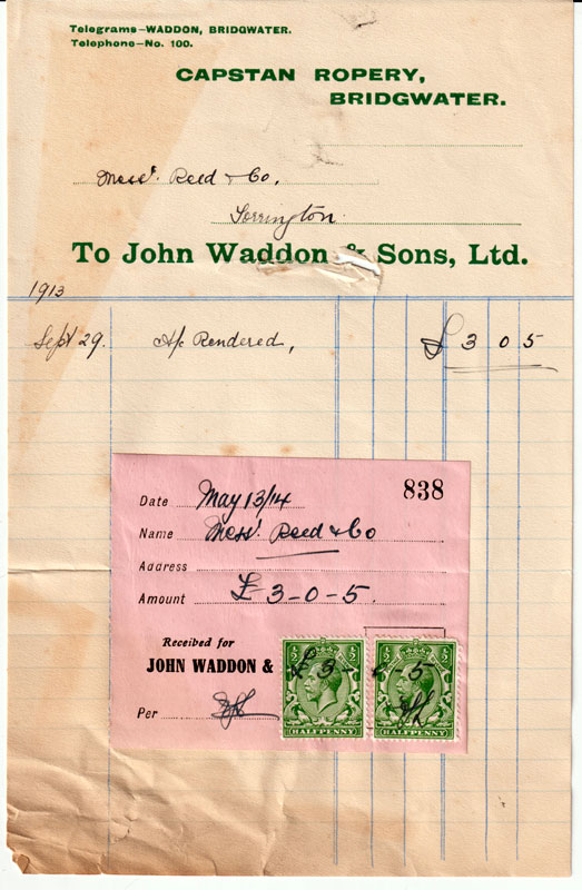
This ropewalk measured approximately 657 feet, or 200 metres, possibly a usable length of 100 fathoms. John Waddon senior died in 1869 but his son John Henry Waddon and then grandson Clifford Charles Waddon continued the business into the twentieth century, using the name ‘Capstan Ropery’.

Their ropewalk structure survived until it was badly damaged by a fire in 1951. After this the site was sold and the land was re developed for commercial properties.
The line of the former ropewalk is more or less preserved by the garden boundaries of the houses on the west side of Church Street.
Modern OS map showing the area of the former Waddon Eastover ropewalk

Thomas Parson’s Chilton Ropewalk 1888
Thomas Rendall Parsons was born in Bridgwater c. 1815, and in 1851 he was working on the railway. However, his father Henry came from West Coker, and maybe some relatives had worked at the West Coker Twine Works. By 1861, Thomas Parsons had made the change from working on the railway to being a rope manufacturer, and it is possible he took over William Peach’s business when William retired. Thomas moved from his previous home in Wellington Place to live in Eastover, where he had a marine store and ran his rope manufacturing business, although it is not known where his ropewalk was at that time.
Sometime between 1871 and 1881, Thomas retired to a property called Escott House on Chilton Street, and he had built a ropewalk behind the house, which can be seen on 1888 OS maps.
1888 OS map showing Thomas Parson’s ropewalk off Chilton Street

This map shows that the whole length of the ropewalk was a permanent structure with a roof. There was a slight dogleg in the building, so it is not clear if the whole length was used as the ropewalk, although there was a through line so it may have been possible. Perhaps one side was the twine walk. Assuming the longest possible length was used, this ropewalk was approximately 517 feet, 157 metres, maybe a usable length of 85 fathoms.
The 1888 Town Plan shows a series of posts on the sides of the longest length. This may indicate that the building had a tiled roof, but at least some of the sides were open.
1888 Town Plan showing construction detail

Thomas Parsons was succeeded by his son Isaac, who continued the business until he retired, which was between 1935 and 1939. Isaac’s son Phillip had predeceased him, and so the Parsons ropewalk probably went out of use when Isaac retired. The 1946 RAF aerial photographs show that the Chilton Street ropewalk was still standing, but the field to the south already had housing on.
Now the area formerly occupied by the ropewalk is completely built up with housing, the line of the ropewalk is close to the road called Brendon Way.
Modern OS map of the area of the former Thomas Parsons Chilton Street ropewalk

The end of the Ropewalks
Six identified ropewalks have been described above. Other, earlier ropewalks must have existed, but records for them have not been found yet. They could have been quite ephemeral, just a long ramshackle wooden shed which could be repurposed or demolished easily.
Some ropewalks have left a ghostly trace – where they were situated close to a field or property boundary, which has been preserved as a modern boundary or path which still shows the approximate line the ropewalk once followed. Examples of this are the path along the southern edge of Browne’s Pond (3. Peach), the alleyway behind the back gardens on the west side of Church Street (5. Waddons), and Brendon Way (6. Parsons).
Rope making in Bridgwater was always done by hand, and when wire ropes became more popular for rigging, the demand for hand-made hemp rope was drastically reduced, spelling the end of the traditional ropewalks.
Postscript: The modern rope walk
A mile of path beside the riverbank has an ultra violet rope embedded in it, to commemorate an important part of Bridgwater’s industrial past. ‘The Rope Walk’ tourist information board has been set up to guide visitors around various sites of interest along the river bank and into the town centre.
Further information about ropewalks and rope making:-
Bridgwater Heritage website, under Trade and Industries, see ‘The Process of Rope Making’ by Charles Tomlinson
Friends of Wembdon Road Cemetery website, see the biography of Henry Broom senior – Appendix 1. Rope making. (Membership required)
Some biographical notes for Bridgwater rope manufacturers
NB A full biography for John Henry Waddon (John Waddon junior) can be seen on the Friends of Wembdon Road website. A biography for Thomas Rendall Parsons is to follow on the same website.
John Trott family biographical notes
John Trott 1. c.? – 1729
First definite record in Bridgwater – 1685, rope maker.
1691 – married Elizabeth Roberts in Bridgwater
Children of John and Elizabeth Trott – Sarah 1692 – 1695, John 1694.
1697 – built the ship ‘Friendship’ for merchant William Alloway
1697 – 1711 John Trott made all the rope required for the work on the bridge and quay.
1729 – burial of Mr John Trott implies status as a respected merchant.
1730s – son of John Trott – John Trott 2, built graving and repairing dock on the east bank.
1754 – John Trott on list of electors as a coal merchant and rope maker.
1790 – listed as a rope maker in the Universal British Directory of Trade
1798 – Land Tax Redemption records in Eastover show John Trott (probably John Trott 3).
1802 – John Trott had been in partnership with John Trott Mills, both sail and rope makers. Their partnership was dissolved 17th December 1802 (notice published in The Star 22 Dec 1802.) John Trott Mills went back to London and was later declared bankrupt in 1804. London Gazette – bankruptcies notices.
1822 – last listing in directories for the Trott family as rope makers.
William Peach 1785 – 1867 biographical notes
Born – 1785 Ilminster, Somerset, son of John and Mary Peach
1814 – first wife Ann Sealy married in Bristol
Children of Ann and William Peach all born in Bridgwater:-
Josiah Sealy 1815 (Anglican), (rest all Wesleyan) William 1816, Frederick 1819, Alfred 1820, Henry 1823, William (2) 1825, Mary Ann 1827.
1827 November – death of wife Ann soon after childbirth.
1828 – William married Charlotte Smith in Shepton Mallet
Children of Charlotte and William Peach all born in Bridgwater, Wesleyan baptisms:-
Mary 1828, Sidney Charlotte 1829, Emily 1830.
1815 – Wm Peach described as a rope maker on his son’s baptism record.
1822 – first listing as a rope maker in Bridgwater – Pigot’s Directory
1832 – electoral register – owned Brooke Acre a freehold property.
1836 – donated land for a chapel in John Street, to the trustees of the Mariners Christian Society[vi].
c. 1840 – owning a ropewalk in Hamp on Tithe map.
1841 and 1851 census records – had a shop/business premises in Eastover, rope maker.
1861 – retired rope maker, living in Monmouth Street.
Other business interests – paper manufacturing (Wansbrough Paper Mill) and railway shareholder.
11/03/1867 – died, buried in St Peter & All Hallows, West Huntspill. (Obit in Somerset County Gazette)
No descendants continued the rope making business.
John Waddon senior 1807 – 1869 biographical notes
Born – Trull, Somerset 1807, son of Robert and Mary, had a younger brother called Henry, born Trull 1823. Henry also worked in Bridgwater as a rope maker, probably together with his brother John.
1835 – John was a widower when he married Susan Crossman in Walcot.
Children of Susan and John Waddon:-– Elizabeth Ann 1836, John Henry 1838, Mary Jane 1841.
1839- listed as a rope maker in Bridgwater – Robson’s Directory.
c. 1840 – renting a ropewalk in Hamp on Tithe map.
1841, 1851 and 1861 census records – had a shop/business premises in Eastover, rope maker.
By 1865 – had a permanent covered ropewalk at the back of Church Street (photo).
1869 – died in Bridgwater, buried in St John’s Churchyard.
John Waddon senior was succeeded as a rope maker by his son John Henry Waddon, who went on to become a mayor of Bridgwater, and who has a full biography on the Friends of Wembdon Road Cemetery website.
References
Somerset Historic Environment Record – Tithe map, OS maps and RAF aerial photographs.
Ancestry.co.uk – census records, county directories, land tax redemption records.
SW Heritage Trust – Bridgwater Council records
A History of Bridgwater by J.F. Lawrence, publ. Phillimore & Co. 2005
Bridgwater Heritage Group – historic maps of Bridgwater
Clare Spicer and Jill Trethewey 01/05/2024
[i] 1685, building a new almshouse – described by J.F. Lawrence in ‘A History of Bridgwater’, publ. Phillimore & Co. Ltd 2005. Records in the Receiver’s Accounts, in the SW Heritage Centre, D/B/bw Bridgwater Borough Records c. 1200 – 1974 SW Heritage, Borough Administration pages 84-115.
[ii] Nine men were executed at Bridgwater, one of them a John Trott from North Petherton, but it is not known if he was any relation to the Bridgwater rope maker.
[iii] The Bowling Green existed during the Seventeenth century when there were references to maintenance costs. Sir Halswell Tynte left it in trust to be used as a bowling green SW Heritage ref. DD/OS/11. This was probably the first Sir Halswell Tynte 1649 – 1702, as the third baronet, also called Sir Halswell Tynte, died young. The Bowling Green was reported in rate books dated 1836, but between 1849 and 1866, the council leased the land for development.
[iv] Watson may have been Thomas Howel Watson, born in Bridgwater in 1804, and Luer may have been George Norman Luer, born in Westminster in 1806. Both Watson and Luer were in the Bridgwater United Grand Lodge (Perpetual Friendship) of Freemasons during the 1830s. Both seem to have been investors, rather than artisans. Watson died in 1859 and Luer in 1858, and this ship building group in Bridgwater ceased trading.
[v] There was a field in or near Eastover called Rope Walk Field, which had a portion reserved for a ropewalk. Unfortunately this field name does not appear on the tithe map, but the British Magazine and Monthly Register in 1845 printed a letter describing the purchase of this land for St John’s Church, Bridgwater. This seems most likely to refer to the site of John Waddon’s Eastover ropewalk, which ran behind houses built on Church Street, close to St John’s Church.
https://www.google.com.au/books/edition/The_British_Magazine_and_Monthly_Registe/FKo2AQAAMAAJ?hl=en&gbpv=1&dq=%22rope+walk%22+bridgwater&pg=PA214&printsec=frontcover
[vi] Somerset Heritage Centre D/N/bmc/2/1/5