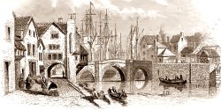


The Island was a row of building running up the middle of the High Street, the north side of which was known as ‘The Shambles’. This split the High Street into two, referred to as the North and South Streets by the middle of the thirteenth century. The Island had as temporary medieval market stalls were gradually made more permanent and eventually replaced with houses.
The name ‘Shambles’ refers to the butchers’ stalls found on the High Street. These could either be independent stalls or else hinged wooden boards attached to the buildings. The name originally derived from the Old English for table, but later came to refer to the meat markets which used these tables. From these meat markets shambles came to refer to slaughter, especially in a military context, and gradually this morphed to mean just a mess.
We get a vivid depiction of the Shambles from Powell’s Bridgwater in the Later Days, (Bridgwater: Page and Son, 1908), p166:
Let us stand, one fine morning in summer, in the early thirties of the last century [1830s], in the High Street of the old town. The Island, a group of houses pulled down more than fifty years ago, stood then in the middle of the street, reacing from the Bristol Arms up to the Mansion House Inn. The end house of all (eastwards) was Mr. Peacock’s the fruiterer’s (at some time it was Bailey’s the trunkmaker). Next to it (westwards) came an opening. Adjoining the opening stood the shop of Mr. Lovern the shoemaker, and just above it was another passage-way through the island houses, just about opposite to the Golden Ball. Next to that came Dean’s the earthenware shop (afterwards the business-place of Mr. Trapnell the clothier). Above it stood the larger house to which Mr. Lovern eventually moved, next below Walkam’s the grocer. Then followed another opening, just opposite the narrow passage leading from the High Street to St. Mary’s Church. The passage way was known as Danger’s Ope. Next above this again came Tilley the barber, and beyond his house White’s the butcher. West of this stood the business abode of Mr Sparry the tinman, and next to it that of Hurford the stonemason. This last house reached up to about half-way in front of the Mansion House Inn. Between this group of houses and the north side of High Street was a narrow road (in front of where Mr. Culliford’s shop now stands) known as the Shambles, where some butchers’ stalls stood. Pain, Richards and Johnson sold meat there in those days, at various stalls, even on Sunday mornings. But when St. Mary’s Church bell ceased ringing the meat selling also stopped.
The Town Council of Bridgwater spent a considerable effort in the first half of the nineteenth century in arranging for the row of buildings to be demolished, although it took them some time to buy up the various leases. Only four buildings survived into the 1840s. The last three buildings came down in January 1856, the final one falling on the 24th.
References
Lawrence, History of Bridgwater, (2005)
Powell, Bridgwater in the Later Days, (1908)
Dunning, Bridgwater History and Guide, (1992)
