Street names in Bridgwater beginning with the letter D.
Daffodil Place: Post 2006 Willstock Estate, date TBC. Named after a type of plant.
Daisey Close: Post 2006 Willstock Estate, date TBC. Named after a type of plant.
*Dampiet Street: The Dam-yett street, the way to the dam (which was attached to the town’s mill in what is now Blake Street). Dampiet seems to have originally included King Street and Blake Street as a broad ‘y’ shape. First mentioned in 1344 (BBA, no.139).
Dampiet Ward: See King Street
Danesboro Road: Part of the Cooperative Housing Estate: appears on the 1955 Town Guide Plan under construction. Name of unknown significance.
Danger’s Ope: See Church Passage
Daulrin’s Buildings: Exact spelling unclear, but mentioned in the 1881 census off of Monmouth Street – most likely Hellier’s Buildings.
Davies Close: Part of the Hamp Developments. Shown under construction on the 1946 RAF aerial photographic survey. Named after Jack Davies, labour councillor.
Daws Close: First appears on the 1978 Town Guide Plan. Many of the roads on this estate were named after notable Bridgwater civic leaders. Identity TBC.
Deacon Road: Part of the middle phase of the Sydenham estate. Not on 1939 Town Guide plan. Complete by 1953 (BFA: EAW051177). Probably refers to Mayor W. Deacon, who served 1925-7.

Deal Close: (late 20th c. Bower development – date TBC) One of a series of streets in a development, mostly named after trees types and flora. Possibly a reference to Deal Lumber.
Denner’s Court: Possibly Preece’s Court in St Mary Street. Eleven cottages and premises known as Denner’s Court in St Mary Street were advertised for sale in November 1878. Most likely named after Robert Denner, a wine and spirit merchant and grocer. For details of his life, see the biography of William Crocker 1829-1889 on the Friends of the Wembdon Road Cemetery website. This court may have been accessible from Silver Street, as a ‘Denner’s/Denman’s Court is mentioned there in the 1881 census (with five households), although there is no obvious way this is possible from the 1854 and 1887 Town Plans. If these are the same then they may also be ‘Russell Court‘ mentioned in Silver Street in the 1861 census.
Devonshire Street: Name of unknown significance. Either the Duke of the County? Possibly in a theme with Polden Street and Wellington Road. Initially laid out around 1860: ‘New streets are in the course of formation over eleven acres of ground belonging to Mr Vidal in St John Street, and in the rear of that thoroughfare. One street will run from Polden Street to the railway station yard, and another from the new road to St John Street. These two thoroughfares are being made, and other transverse streets are to be laid out’ Bridgwater Mercury 4 April 1860. We learn elsewhere in that edition of the paper that Mr Vidal was employing the workmen to build the scheme – a Mr Lilly was also involved. Vidal was to be charged 10 shillings for each ‘entry into the St John Street drain’, which perhaps explains why this street was joined onto Polden Street, not directly onto St John’s. For the building of 33 and 35 Devonshire Street in 1870, see here.
Devonshire Way: Modern Little Sydenham Estate, post 2006 – date TBC. Unclear significance. Built over a field called Lower Blind Yeo (TAM), suggesting that this was the site of a silted up tributary or course of the Parrett – Yeo being a common river name, blind meaning it came to a dead end.
Dewberry Avenue: Post 2006 Willstock Estate, date TBC. Named after a type of plant.
Dexter Walk: Post 2006 Stockmoor Estate, date TBC. Name of unclear significance. Dexter is the Latin term for the right hand side.
Docks: Bridgwater Docks or Floating Harbour. Opened 25 March 1841. Closed 1971. Converted to a Marina in the 1980s.
Dole’s Buildings: courtyard of about five cottages adjoining Violet House in a lane off of Monmouth Street. Presumably named after its builder. Shown on the 1889 OS 25″ Town Plan. Named in the 1881 census. Still standing on the 1930 OS map. Called ‘No. 3 Court’ in the 1937 Whitby Light and Lane Town Directory. Now the site of Slocombe’s Close.
Dorset Road: Westonzoyland Road Estate, laid out and built between 1961 and 1967 (Town Guide Street Plans). Counterpart to Somerset Road, being West Country shires.
Dovai: NDR development, complete by 2006. Name of unknown significance. Possibly a reference to Walter of Douai, whose forename gives the Water in Bridwater. Built over a field called ‘Tuttles’.
Downhall Drive. Wembdon. The drive to Down Hall House. Originally a straight lane north of Church Lane to the old quarry behind the big house, shown on the 1840s Tithe Apportionment Map. By the 1889 OS map the lane had changed to a curving driveway leading to ‘Elm Grove House’, another name for Down Hall, or at least the west most portion of it. ‘Down’ was presumably the surname of the person who built the house (TBC).
Drakes Close: (1980s Docks development – date TBC) Named after famous admirals of the Royal Navy, keeping with the notion of ‘Admirals Landing’. Named after Sir Francis Drake.
The Drove: A name referring to trackways along which livestock could be taken. Unclear how old this feature is, and whether it pre-dates Bristol Road, or is part of that development with the Leggar and Union Street. ‘Drove’ was also applied to a number of other trackways around the outskirts of the town, such as what is now Victoria Road.
Duchess Close: Modern NDR development, complete by 2006. One of a series of names taken from aristocratic titles. Built over a field called Waverlands (TAM).
Duddridge’s Building (16 to 26 Rhode Lane): a Victorian terrace, presumably named after the owner/builder. Shown as proposed/under construction on the c.1854 Town Plan alongside the adjoining Victoria Terrace (4-14 Rhode Lane)
Duke Street: Modern NDR development, complete by 2006. One of a series of names taken from aristocratic titles. Part built over the site of an orchard on the 1840s Tithe Apportionment Map.
Dukes Mead: Modern addition to the Hamp Estate (date TBC). Name ‘the meadow of the duke’ is of unknown significance – no apparent historical precedent, presumably just made up to sound grand.
+Dunball: Old English for ‘prominent hill’ (Ekwall)
Duncombe Close: Modern Bower development, date TBC. Name of unclear significance to Bridgwater, Duncombe not being in Somerset – possibly refers to the place in Lancashire.
Dunkery Road: Part of the Co-operative Housing Society Quantock Road estate, shown under construction and not yet named on the 1955 Bridgwater Town Plan. Named after the village on the Quantocks, which comes from the Old Welsh for ‘hillfort on the rock’ (Ekwall).

Durleigh Close: A modern development, date TBC, built over the site of the old Vicarage of St Mary’s Church, dating to c.1851. Takes its name from Durleigh Road.
Durleigh Hill: Durleigh means something like the ‘wood frequented by deer’ (Ekwall). A very old trackway leading to Road.
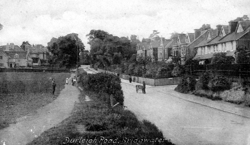
*Durleigh Road: The road to Durleigh: A very old trackway leading west of the town. Shown as ‘Enmore Road’ on early maps. On the 1889 OS map there is very little development past Northfields, save farms, St Mary’s Vicarage and West India House (which is also on the 1840s Tithe Apportionment Map). Secondary School built in 1937 (Squibbs)

Dyer’s Buildings: A court in North Street, mentioned somewhere between the North Pole Inn and the Compass Inn. Named in the 1871 Census, at which time there were five cottages. Gone by the time of the 1887 25″ OS Map – possibly replaced by Nursery Cottages, unless they were the cluster of buildings set back from the road by the canal.
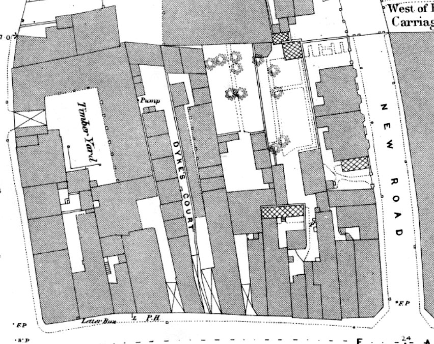
Dyke’s Court: A court on the north side of Eastover. Appears on the 1887 OS 25″ Town Plan (see below). Presumably named after the owner at the time. In the 1865 railway submission to Parliament it was owned by a Benjamin Baker (with thanks to Dave Bown). In the 1881 census it was called Baker’s Court. Still standing on the 1930s OS map.

