Street names of Bridgwater starting with the letter F.
Fairfax Close: Later addition to Fairfax Road – not in the first phase shown in 1946. Shown on the 1967 Town Guide Plan. Built near the site of a medieval windmill.
Fairfax Road: The northern portion meeting Wyndham is shown in the 1939 Town Guide, likewise in the 1946 RAF aerial photographic survey. The southern portion is not yet under construction by 1953 (BFA: EAW051177). Shown complete on the 1967 Town Guide Plan. The name refers to Sir Thomas Fairfax, who stormed Bridgwater in 1645. His adversary was Colonel Wyndham, whose street is a counterpart to this one.
Fallow View part of the 2018 Durleigh Gardens Estate, which took its name from species and types of deer (with thanks to Laura Bailey).
Farthing Road: Part of the Wills Road ‘Quantock View’ Estate, which was being built from at least 1986 onwards (see Wills Road). Most names on this estate are named after Bridgwater worthies. This one is named after Walt Farthing, mayor of Bridgwater in 1939 and MP for Frome who lived in Blacklands (BS).
Fenner’s Buildings: Court on the north side of Eastover, behind the property three doors down from what is now the Cobblestones pub. Appears on the 1888 OS Town Plan. Presumably named after the owner and/or builder. Seems to have been demolished by the time of the 1904 OS map. Called Collard’s Court on the 1891 census, again, presumably referring to the owner.
Fernleigh Avenue: Built over the site of several orchards (TAM and 1889 OS). The east had been begun by the 1930 OS map and shown completed by the 1949 RAF survey. Name of unknown significance.
Feversham Avenue: Part of the 1930s Newtown development. Not yet begun on the 1930 OS map, although Kendale Road shows the anticipatory junction. First appears unnamed on the 1930 Town Guide Plan, then named on the 1931 Town Guide Plan. Shown complete on the 1949 RAF survey. Name of unknown significance. Extended to Trinity Way in circa 2001 with the NDR development.
Fig Tree Crescent: Post 2006 Willstock Estate, date TBC. Named after a type of plant.
Fir Tree Close: First shown on the 1978 Town Guide Plan. One of a series of streets in a development, each named after trees types.
Florence Court: NDR development, under construction in 2006. One of a series of names taken from places in Italy. Built over a field called ‘Rag’ (TAM).
*Fore Street: Fore meant preeminent in the same way as ‘High’ in High Street (think High Lord Admiral) and was a common West County means of indicating a town’s most important street. Once part of what was considered the ‘Great Street’ or ‘Great Royal Street’ which ran from the West Gate (Penel Orlieu) to the town Bridge, via the Cornhill, and described as such in the 1260s (BBA, nos 16, 21, 24 and 37). Even called High Street in a document of 1355 (BBA, no 176) In 1540 John Leland considered High and Fore Street to be the same, despite being disjointed by the market place/Cornhill. First recorded as ‘Forstret’ in 1367 (BBA, no.237). Also described variously as ‘Twixt Church and Bridge’ in 1355 (BBA, no.176), or ‘Twixt Bridge and Market’ in 1355 (BBA, no.176), or ‘Twixt Bridge and Chuchyard’ in 1373 (BBA, no.283). The row of properties on the north side of the street was known as ‘Castle Ditch’ by 1367, indication that this portion of the moat had been built over by this time (BBA, nos 235, 283) – another document mentioning a half burgage on the west side of castle ditch in 1317 (presumaby in the Cornhill area) might suggest earlier, although it is not clear if this may have just abutted the moat (BBA, no.77).
Forester Close: Post 2009 Jam Factory redevelopment. Some streets on this estate took nautical names associated with the River Parrett. Two ships bore the name on the river: one recorded in 1920, the other, the Royal Forester, is recorded 1848-1866 (Reference Index).
Forsynthia Way: Post 2006 Willstock Estate, date TBC. Named after a type of plant.
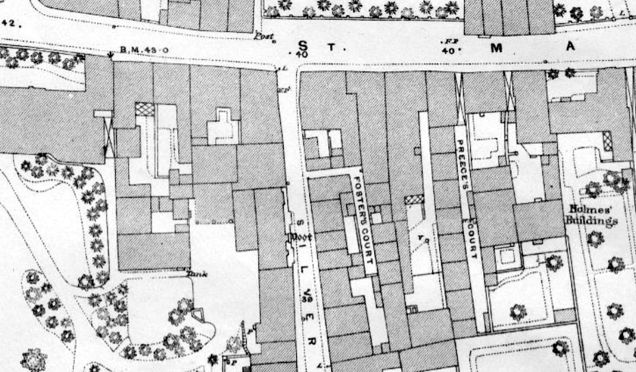
Foster’s Court: Silver Street. Consisted of four small half houses. Presumably named after the builder/owner – possibly something to do with Mayor Foster and his family. No buildings shown on the 1854 Town Plan, but first mentioned in the 1861 census, implying it was built sometime within those five years. Also mentioned in the 1881 and 1901 censuses. Shown and labelled n the 1887 OS Town Plan. Still standing on the 1930 OS map, but not mentioned in the 1938 Whitby Directory. They also seem to have been called ‘Number 1 Court Silver Street’ (Langport & Somerton Herald, 10 December 1904)

Four Acre Meadow: Part of the NDR development, complete by 2006. Takes its name from the field it was built over, recorded on the Tithe Apportionment Map.
Foxglove Walk: Post 2006 Willstock Estate, date TBC. Named after a type of plant.
Frampton Road: Part of the Wills Road ‘Quantock View’ Estate, which was being built from at least 1986 onwards (see Wills Road). Most names on this estate are named after Bridgwater worthies. Named by Brian Smedley in honour of two famous Framptons: 1. Nicolas Frampton, the Hedge Priest vicar of St Mary’s during the Peasants revolut of 1381 and Robert Frampton, the Dockers’ Union leader during the 1896 Brickyard strike.
Frederick Road: Northern portion shown in the 1939 Town Guide. Partially built on the 1946 RAF survey. Complete by 1953 (BFA: EAW051177). Built over a field called ‘Mile Stone Six Acres’ (TAM). Probably named after the Cardiff-based builders of Frederick and Trevor Moss (with thanks to Heather Prosser)
Friarn Avenue: Built 1934, when part of the medieval Friary buildings were discovered. Takes its name from Friarn Street, which in turn took its name from the friary this avenue was partially built over.
Friarn Lawn: Takes its name from Friarn Street, lawn because there was a large private garden to the front, now built over by the Broadway. Built as a private street for the new terrace, built circa 1820. Once terminated in a grand house called ‘The Friars’.
*Friarn Street: The street with the Franciscan Friary. The Friary was founded in 1246. First mentioned, ‘Frerenstrete’, in 1298 (BBA, no.44). Possibly called the Wayhur before the Friary was founded (see Horsepond Lane). Parts were also referred to as ‘twixt South Gate and Friars Minor’ in 1345 and ‘twixt West Gate and Friars’ in 1361 (BBA, nos 143 and 193). Part demolished for the Broadway, 1963 (Blake 2)
*Frog Lane: Mostly destroyed by Binford House, now Blake Gardens, a portion survives as Binford Place. The summer house in Blake Gardens stands on the site of the former lane. ‘Frog’ was a common epitaph for medieval placed that were unusually wet and boggy – unsurprising given the proximity to the river.
Furlongs Avenue: Built on the site of Hamp Wood on the 1840s Tithe Apportionment Map, then open fields by the 1889 OS map. Shown under construction on the 1946 RAF aerial photographic survey. A furlong was a common unit of distance and often given to field names.
Fursland’s Buildings: numbers 71-95 Old Taunton Road: The terrace partially occupies the site of the medieval chapel of St Saviour’s. Open fields in the 1810s Town Plan, appear to be planned or under construction on the c.1854 Town Plan. Presumably named after the builder or owner. Numbers 67-69 added by 1904.
Fursland’s Court, West Street: a row of ten cottages behind two more fronting the north side of West Street, separated by a section of garden. Named on the 1887 OS 25″ Town Plan and in the 1881 Census, but not named at all in the 1871 Census. Shown on the c.1854 Town Plan. Still standing in 1954 (Britain from Above: EPW039924). Named number 12 court by 1937. Presumably named after the builder or owner, probably the same man as Fursland’s Buildings in Old Taunton Road.
Furze Close: Built over the site of the former Girl’s Grammar School. Modern, date TBC. Named by Jan Farrance after the head of the former school, Miss Furze, who succeeded Phillips and Nicholls, who are also commemorated by near by roads. (with thanks to Molly Warren and Dawn Ferguson).
