Street names in Bridgwater beginning with the letter ‘J’.
Jacob’s Land: See Blake Place.
Jade Close: Modern Little Sydenham Estate, post 2006 – date TBC. A number of roads on this estate are named after pretty stone types. Built over a field called ‘Hither Thirty Acres, as opposed to ‘Yonder Thirty Acres’, presumably in relation to Cockpit Farm. (TAM).
Jam Factory Lane: The lane running between Wembdon Road and Halesleigh Road. While one side was bounded by the Wembdon Road Cemetery, the other was bounded by the ‘Jam Factory’. Originally Churchill’s brewery, it was converted into a preserving factory in World War One, and later was home to the Somerset Preserving Company. Latterly part of Gerber Foods. Site redeveloped in 2011, although the boundary wall still runs along the lane.
James Buildings: Mentioned in the 1841 Census on the north side of West Street. Unclear where these were. The census lists them 10 properties to the west of Milton’s Court, but this does not correspond with the later maps. Possibly Jones Buildings?
Janson Close: (late 20th c. Bower development – date TBC) unknown significance.
Japonica Close: (late 20th c. Bower development – date TBC) One of a series of streets in a development, each named after trees types.
Jasmin Close: Part of the Willstock Estate. Named after a type of plant, as were other streets in this development. Google Street view indicates that building was onoing in the Autumn/Winter of 2010 to Summer 2011 and beyond (with thanks to Jon White)
Jenkins Buildings: Mount Street. Small terrace, named on the 1901 census. Built sometime between the 1854 town plan and the 1887 OS Town Plan. Presumably named after the builder or owner. Still standing at the time of the 1930 OS map, but gone by the 1946 RAF survey – presumably demolished along with the Old Market.

Jewel Close: Modern Little Sydenham Estate, post 2006 – date TBC. A number of roads on this estate are named after pretty stone types. Built over a field called Lower Blind Yeo (TAM), suggesting that this was the site of a silted up tributary or course of the Parrett – Yeo being a common river name, blind meaning it came to a dead end.
Jones’s Court, West Street: Shown and named on the 1887 OS Town Plan, although seem to only consist of two dwellings behind the house on the street front. Only two households in the 1881 Census, not named in the 1871 census. One of the two dwellings is shown on the c.1854 Town Plan. Possibly ‘James Buildings’ on the 1841 census, but this is difficult to square with the map evidence. Only one dwelling again on the 1904 OS map. Presumably named after the builder or owner – no Jones listed in 1871 or 1881. The 1889 Whitby & Son’s Directory mentions a William Jones ‘House Agent’ living in Northgate, who may have been the landlord.
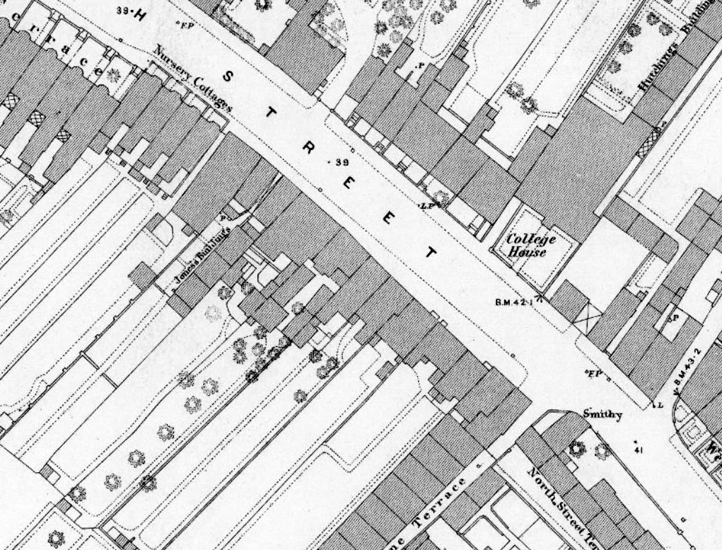
Jones Buildings, North Street: A small row of cottages behind number 19 North Street. Named Jones’ Buildings on the 1887 OS Town Plan, although called Kitch’s Court on the 1871 Census, Kitch’s Buildings in the 1881 Census and Gibb’s Buildings in the 1908 and 1937 Whitby Light and Lane town Directories (with thanks to Peter Redding). Shown built on the 1854 Town Plan. The name Kitch’s Court refers to the property’s ownership by a man named Kitch, although this man was not living at the property on the 1871 census. Most likely James Hellier Kitch, builder and contractor of Salmon Parade (Heritage Group Collection, Indenture for 17 North Street, Boulting to Dyer, 24 June 1876; Whitby & Son’s Directory, 1883). In the 1881 Census we find in the 3rd property listed a Charles Kitch, a 38-year old bricklayer, his 33 year old wife Eliza (or Elizabeth) and his six children. He could be the builder, or perhaps a relative of James Hellier? Jones’ Buildings may refer to a later owner, although a Reece Jones owned the next door house (number 17) in the previous century, from 1727/8 (Somerset Hertiage Centre DD/Z/WBB/1073). Still standing in 1930. The cottages look to have been demolished by 1953 (Britain from Above EAW051174)

Jubilee Close: Shown as a new addition to the map of the 1978 Town Guide. Along with adjoining Elizabeth Way, this is a reference to the silver jubilee of 1977.
Juniper Close: (late 20th c. Bower development – date TBC) One of a series of streets in a development, each named after trees types.
Jutland Walk: Post 2006 Stockmoor Estate, date TBC. Most likely named after the type of cattle, give the livestock theme of this estate. There was a famous battle at Jutland in 1916 – at least three Bridgwater men were killed there.