Street names of Bridgwater starting with the letter L.
Laburnum Close: First shown on the 1978 Town Guide Plan. One of a series of streets in a development, each named after trees types.
Ladymead Close: Part of the cooperative housing state: built between the 1972 and 1974 Town Guide plans. Lady mead would mean the meadow belonging to St Mary, so is presumably a nod to the nearby Roman Catholic Rosary nursing home.
Lakeside Park: Modern Caravan park built over and beside a former brickyard clay pit (ie the ‘lake’).
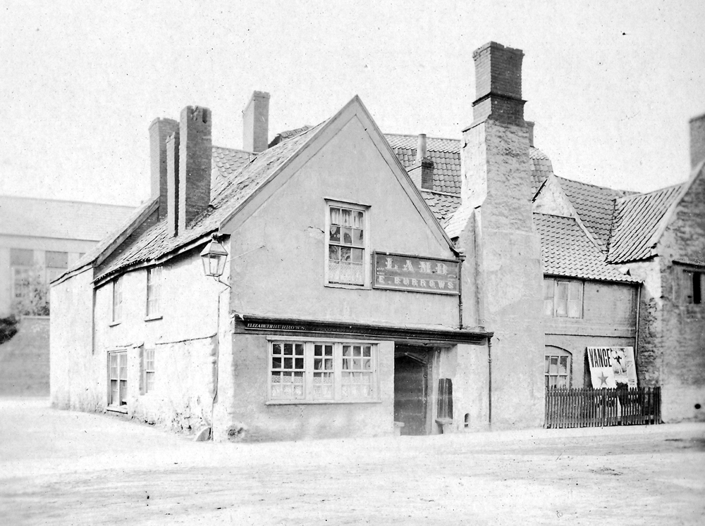
*Lamb Lane: Between High Street and Little St Mary Street. Named after the adjoining Lamb Inn (now the Monmouth), the Inn first mentioned in 1644. As with most early Inns, the Lamb is probably a reference to ‘the Lamb of God’.

Lancaster Close: Modern Little Sydenham Estate, post 2006 – date TBC. Name of unclear significance, possibly named after the town or the World War Two Bomber.
Langport Quay/Slip: See Binford Place
Larch Close: (late 20th c. Bower development – date TBC) One of a series of streets in a development, each named after trees types.
Larkspur Road: Post 2006 Willstock Estate, date TBC. Named after a type of plant.
The Laurels: Wembdon. Date TBC, modern. Presumably named after trees planted here.
Lavender Walk: Post 2006 Willstock Estate, date TBC. Named after a type of plant.
Lavinia Way: Post 2009 Jam Factory redevelopment. Some streets on this estate took nautical names associated with the River Parrett. The Lavinia was a ship seen in a postcard at West Quay dated 1914. Sunk in 1915 (Reference Index).The ship probably took its name from Lavinia, a character in Virgil’s Aeneid.
Lee’s Court: Friarn Street. A row of cottages built behind 43 Friarn Street (once the Seven Stars public house). Called Lee’s Buildings in the 1891 census, presumably after the owner/builder. Possibly renamed to Number 3 Court by the 1901 census. Still standing in the time of the 1930 OS Map, although not mentioned in the 1937 Whitby Directory. They do not seem to be standing by the time of the 1946 RAF photographic survey.
Leeward Close: date TBC. Built over part of the side of the former Clark’s Redgate Factory – the road is named after Clark’s Clippers, one of their show brands (with thanks to Mike McGeown).
The Leggar: Does not appear on the 1819 Town Plan, 1824 Water Supply Plan or the 1835 Borough Boundary Map. First seen on the 1840s Tithe Apportionment Map. Presumably contemporary with the creation of Church Street in the 1840s, providing a cut-through from Bristol Road, and cuts over various older field boundaries. Possibly originally intended as a continuation of Church Street. Leggar was a name often given to fields with bends in and can be found at various sites in Somerset (Pers Comm Peter Randle).
Lewis’ Court, West Street: A court on the south side of West Street, at the end nearer St Matthew’s Field. Named in the 1871 and 1891 censuses, shown on the 1853 Town Plan and labelled on the 1887 OS 25″ Town Plan. Briefly called ‘Lewis’ Cottages‘ in the 1881 Census. Presumably named after the builder or owner. Renamed Number 9 Court by the time of the 1901 census. Still standing at the time of the 1937 Whitby Directory. Gone by the 1960 Kelly Directory.
Leyton Drive: Bower development. Unclear significance, presumably a surname. Or could be named after the Essex town.
Liberty Place: Appears as the name of the row of terrace housing on the 1889 OS Map, when they overlooked the large marshy clay pits of the Salmon Lane Brick and Tile Works. Presumably dates to the 1840s and the St John Street development. Of unclear significance, although presumably just a generically positive name. On the 1889 OS 25″ Town Plan, the lane on which Liberty Place stands leads to a ‘Liberty Cottage’. This name is puzzling as on the 1861 census this is ‘Chubb’s Cottage’ and this is how it is still known (with thanks to Lesley Watson for pointing this out). It may be a mistaken assumption on the part of the mapmaker, or possibly a very short-lived alternative name for the cottage, linked to Liberty Place.
Lilliana Way: Post 2006 Willstock Estate, date TBC. Name of unclear significance. Built over a field called ‘Long Rap’ (TAM).
Lime Tree Close: First shown on the 1978 Town Guide Plan. One of a series of streets in a development, each named after trees types.
Limousin Way: Stockmoor Estate, built 2009. Named after a type of French cow – many of the streets on this estate are named after types of livestock (with thanks to Gary Tucker)
Linden Close: Westonzoyland Road Estate, laid out and built between 1961 and 1967 (Town Guide Street Plans). A reference to a tree type, as are several streets in this estate are. Built over a field called Chick’s Seven Acres (TAM).
Linham Road: Name of unknown significance. Built over the site of what had been a car dealership in the 1980s, and prior to that the Saltlands Brickworks. This estate was built between 1995/96 (with thanks to Jon White).
Linley Close: Modern Bower development, date TBC. Marshland on the 1840s Tithe Apportionment map. Name of unknown signifcance.
Lock’s Court: See Cole’s Buildings.
Logan Grove: Part of the new 2024/2025 Bower estate called ‘Strawberry Grange’ by Countryside Homes, all of the streets taking their names from types of Berry (with thanks to Laura Bailey). Partly built over fields called ‘Broad Loose’ (TA). ‘Loose’ is possibly from the Old English for ‘Pigsty’.
Long’s Court, West Street: A court on the south side of West Street. Named in the 1871, 1881 and 1891 censuses, shown on the 1854 Town Plan and labelled on the 1887 25″ OS Map. Not apparent in the 1841 census, so built between then and 1854. Presumably named after the owner or builder. Renamed number 5 Court by the time of the 1901 Census. Still shown on the 1930 OS Map; mentioned in the 1935 Whitby Directory, but gone by the time of Whitby’s 1937 Directory.
Longhorn Drive: Post 2006 Stockmoor Estate, date TBC. Named after a type of cow.
Longstone Avenue: Still open fields in 1953 (BFA: EAW051177) Shown on the 1967 Town Guide Plan. Built by 1957 at least (with thanks to Carolyn Stevens) Name of Unknown significance.
Lords Close: Modern NDR development, complete by 2006. One of a series of names taken from aristocratic titles.
Lorne Terrace (Old Taunton Road): a terrace still standing consisting of 6 to 16 Old Taunton Road. The front gardens follow the line of the old Middlestream Rhyne. Not yet built on the 1854 Town Plan, or the 1875 Plan. Shown complete on the 1888 OS Town Plan. The significance of the name is unclear. Possibly a reference to John Campbell, the Marquis of Lorne (1845-1914 – later Duke of Argyll) who married Princess Louise (1848-1939 – fourth daughter of Queen Victoria) in 1871.
Losino Close: Post 2006 Stockmoor Estate, date TBC. Name of unclear significance. Possibly refers to the place in Poland, although may be the type of horse.
Lotus Drive: Part of the Willstock Estate. Named after a type of plant, as were other streets in this development. Google Street view indicates that building was onoing in the Autumn/Winter of 2010 to Summer 2011 and beyond (with thanks to Jon White)
Loxleigh Avenue: Site of a clay pit on the 1889 OS map. Not yet laid out on the 1904 OS Map. Northern portion appears on the 1930 OS map and shown in the 1939 Town Guide plan. South portion not built on the 1946 RAF survey. Name of unknown significance, possibly Robin Hood?
Loxleigh Gardens: Old trackway from the Old Westonzoyland Road/Penzoy Avenue to the buildings of ‘Foundry Farm’, now called Bridge Farm. Date of modern houseing TBC the western side is built over an old clay pit. Takes its name from Loxleigh Avenue.
Loxleigh Terrace: numbers 93 to 125 Chilton Street. Built sometime between the 1887 and 1904 OS maps.
Lucerne Crescent: Post 2006 Willstock Estate, date TBC. Named after a type of plant.
Ludlow Close: Open field on the 1946 RAF survey. Shown newly built on the 1974 Town Guide plan. Possibly named after the racecourse, along with Chepstow Avenue and Ludlow Close (with thanks to Laura Bailey).
Luxborough Road: M Part of the cooperative housing state: partially built in the 1971 Town Guide plan and complete by the 1974 Town Guide plan. Names after the village on Exmoor, not far from Dunster.
Lyndale Avenue: Originally built as a private road off of Victoria, a cul-de-sack which terminated in a large wall sometime between the 1889 and 1904 OS maps. Mention of building work here is mentioned in the 1898 Borough Sanitary Report. The bottom part of this road with the newer houses was built in 1927-8, as part of the Newtown Estate, by Pugsley of Bristol, although it took a few years for the two portions of the road to be joined up. (Locke)
Lyndhurst Crescent: Wembdon. Modern development, first shown on the 1978 Town Guide Plan. Name of unknown significance. Built over a field called ‘Cheek’s Meadow’.
Lyndhurst Terrace: Taunton Road, numbers 79 to 101. Built between the 1887 and 1904 Ordinance Survey Maps. Name of unclear significance.
