Street Names in Bridgwater beginning with the letter ‘C’.
Cambridge Drive: Modern Little Sydenham Estate, post 2006 – date TBC. Possibly a reference to the creation of Prince William and Kate to Duke and Duchess of Cambridge in 2011. Otherwise it may just a pleasing name to sound grand. Built over a field called Lower Blind Yeo (TAM), suggesting that this was the site of a silted up tributary or course of the Parrett – Yeo being a common river name, blind meaning it came to a dead end.
Camden Road: Unknown significance, possibly named after a person (such as the historian) or after the place in London – possibly part of the late nineteenth century trend for British towns and cities to name streets after London landmarks (such as Charing Cross). The south-most part was called ‘Timberlake’s Garden’ on the 1840s Tithe Apportionment map, and was a nursery on the 1888 OS map. Among the Gibson architectural drawings we find mention of 8 houses designed in February 1897; more houses from August 1898; 16 more houses from April 1899; 13 houses from June 1899 (Gibson A\CMY/18, 95, 110 189). The 1904 OS map shows Camden and Blacklands almost complete, save for 7 or 8 houses in the north western corner. Sometimes spelled as ‘Cambden‘ and ‘Camdon‘ prior to 1906 (Stillbirths register for the Wembdon Road Cemetery –with thanks to Clare Spicer).
Campion Way: Post 2006 Willstock Estate, date TBC. Named after a type of plant.
Canal View: Modern bungalows in a small lane off of Taunton Road, just north of the canal bridge and behind Clayfield Villa. Date TBC. They overlook the canal, hence the name. Built over the site of Browne’s Cottages, a small terrace of eight or nine cottage for brick and tile workers, named after the builder and owner, William Browne (1791-1859). They were accessed via a small lane along the canal bank. It is unclear when these cottages were built, they don’t seem to be on the 1840s Tithe Apportionment Map, although they do appear on the c.1854 Town Plan. Called Browne’s Buildings on the 1904 OS Map. Can be clearly seen on Aerial Photographs of 1935 of the gas works (Britain from Above EPW048424). They seem to still be standing in 1953 (Britain from above EAW051176).
The Cannon: See Cross Rifles
Cannon Close: Modern development, built by 2006. Takes its name from the cannon on the roundabout (see Cross Rifles). The site of a coal yard and a row of cottages called ‘Bathroad Place‘ on the 1888 OS Town Plan. These were still standing at the time of the 1946 RAF photographic survey.
Canworth Way: (Late 20th c Westonzoyland Road development – date TBC) Unknown significance.
Capes Close: named after the Rev John Moore Capes, who built St John’s Church, Eastover, in 1846, and was the first Vicar. See Squibbs 43 (Check St John’s book, Capes Dates and Street layout)
Caradon Place: late 20th century (1980s?) Chilton Street development. Unknown significance. All the streets on this development appear to have taken ‘c’ names.
Carlton Drive: late 20th century (1980s?) Chilton Street development. Unknown significance. All the streets on this development appear to have taken ‘c’ names. The northern part is built over a field called Escott’s Marshes (TAM)
Carlton Terrace: 1-11 Rhode Lane. Built between the 1891 and 1901 Census. Name of unclear significance.
Carlyle Terrace: Bristol Road. Built sometime after the 1886 OS map. Most likely named after the writer Thomas Carlyle 1795-1881.
Carolina Close: Post 2006 Stockmoor Estate, date TBC. Name of unclear significance.
Carpathian Way: Post 2006 Stockmoor Estate, date TBC. Presumably named after the central European mountain range. Built over a field called ‘Hawk’s Nest’ (TAM).
Carver Close: Post 2009 Jam Factory redevelopment. Some streets on this estate took nautical names associated with the River Parrett. Named after the Carver family of shipwrights who had a yard on East Quay, and built ships like the Irene.
Carvers Road: Now a former extension of New Road as it headed north to meet East Quay. Originally applied to a road running parrallel to Watson’s Lane, now the site of the supermarket (c.2003/4), and ending in Rope Walk, which connected it to Church Street. Named after the Carver family who ran the Ship Builders’ Yard on East Quay. Road appears, unnamed on the 1961 Town Guide Plan. Named on the 1963 Town Guide Plan.
Cassia Close: Post 2006 Willstock Estate, date TBC. Named after a type of plant.
Castle Ditch: See Fore Street
Castle Moat: A new road built in 1988, joining North Gate, Clare Street and King Square. The long stretch is built over a plot of land that formed part of the medieval moat of the castle. The stretch nearest King Square was excavated by Bob Croft, revealing the robbed out remains of the castle’s curtain wall, and the top of the moat. Further excavations were carried out in 2002 on the north east corner
Castle Street: Initially planned in September 1721 by James Brydges, first Duke of Chandos (1673-1744), to be built over the formal gardens of Bridgwater Castle. By the end of 1723 five houses were under construction with more to follow in the initial phase up to 1727. Initially the street took the form of an avenue with elegant town houses leading from the river to the grand house converted from the an internal gatehouse of the old castle (now King Square), with a possible plan to build a square around it: Chandos considered demolishing the castle in March 1723 and continuing the street onwards, although neither plan came to pass. Initially referred to as New Street or Castle Street, Chandos pushed for it to be named after him (Baker & Baker, The Life and Circumstances of James Brydges, first Duke of Chandos (Oxford University Press, 1949), pp.221-235). By 1737 it was called both Chandos Street or Castle Street. Chandos refers to its founder, James Brydges, Duke of Chandos. Called Chandos Street on the 1735 Stratchey Map. Called ‘Great Chandos Street by the 1810s‘. Still called Great Chandos Street in the 1861 Census. However, it was also referred to as Castle Street on the 1777 Anderdon/Locke Map. Now only known as Castle Street, while the small back street of this development, for some time ‘Horn Alley’ or ‘Little Chandos Street’ is now Chandos Street.
Castlefields: Castlefields once encompassed the area north of Eastover, bounded roughly by the river on the west, Bath Road on the east, what is now the clink on the south, and a marsh on the north. These were fields that made up part of the landed estate of Bridgwater Castle (on the opposite side of the river and to the south) and would have been used to graze cattle, horses and other livestock. Over time these fields were divided up into smaller units and sold off. There were already brick and tile works on parts of the fields on the 1940s Tithe Apportionment Map, there were large clay pits by 1888 and even more by the 1904 OS maps. A football pitch appears on the only un-dug field on the 1949 RAF survey.
Catalana Way: Post 2006 Stockmoor Estate, date TBC. Name of unclear significance. Possibly the type of pudding?
Cavallo Walk: Post 2006 Stockmoor Estate, date TBC. Name of unclear significance.
Cedar Close: (Late 20th c Westonzoyland Road development – date TBC) A reference to a tree type, as are several streets in this estate are. Built over a field called ‘Broadland’ (TAM)
Celandine Way: Post 2006 Willstock Estate, date TBC. Named after a type of plant.
Chamberlin Avenue: Part of the Sydenham Estate. Not on 1939 Town Guide plan. Complete by 1953 (BFA: EAW051177)). Called Chamberlin Road on 1961 Town Guide plan. Named after a Lieutenant-Colonel R. Chamberlin, mayor of Bridgwater 1944, 1945 and 1946 and OBE on 11 June 1942 for his work with the Somerset Home Guard. Note the spelling as Chamberlin, not Chamberlain. Although some histories give the latter (eg Squibbs), contemporary sources give the former (with thanks to Peter Randle for notes on the man and the name).
Chandos Street: Laid out in the Summer of 1726, although initially only vaguely referred to as Back Lane or ‘behind Dr Allen’s House’ (Baker & Baker, The Life and Circumstances of James Brydges, first Duke of Chandos (Oxford University Press, 1949), pp.221-235). Called Horn Alley on the 1777 Anderdon/Locke Map. Called Little Chandos Street in the 1810s. Presumably the official name was the latter, but informally known as the former. Chandos refers to the Duke of Chandos (see Castle Street, above). ‘Horn’ was often used to refer to either a steep peak or an overhanging projection, so this could be a reference to the sharp incline from the quay to the street over the former site of the castle walls. ‘The present Chandos Street is of little credit to the Duke’s name’ (Baker & Baker, Chandos (1949), p.225). Possibly called ‘North Back Street’ in 1735.
Channi Drive: Post 2006 Stockmoor Estate, date TBC. Name of unclear significance.
Chantilly Walk: Post 2006 Stockmoor Estate, date TBC. Possibly named after the place in France.
Chapel Street: Refers to the Wesleyan Chapel of 1818, and post-dates this. Otherwise considered part of either Dampiet Street or Binford Place.
Charolais Drive: Post 2006 Stockmoor Estate, date TBC. Presumably named after the type of cow.
Charbray Road: Post 2006 Stockmoor Estate, date TBC. Presumably named after the type of cow.
Charford Court: Post 2006 Stockmoor Estate, date TBC. Name of unclear significance. Built over a field called Priest Meadow (TAM).
Charlton Close: Part of the later southern phase of the Sydenham estate. Still open fields in 1953 (BFA: EAW051177). Shown on the 1967 Town Guide Plan. Name of unknown significance.
Charnwood Close: late 20th century (1980s?) Chilton Street development. Unknown significance. All the streets on this development appear to have taken ‘c’ names.
Chatham Avenue: Part of the Newtown development. Not yet built on the 1930 OS map. First appears unnamed on the 1930 Town Guide Plan, then named on the 1931 Town Guide Plan. Houses certainly built by 1936, so presumably opened around 1935 (with thanks to Joyce Hurford). Name of unknown significance, possibly a naval reference?
Chatsword Drive: Modern Little Sydenham Estate, post 2006 – date TBC. Little apparent significance: just a pleasing name to sound grand. Chatsworth is a well-known grand house.
Chepstow Avenue: Shown newly built on the 1974 Town Guide plan. Built over the driveway and gardens of Hamp House. Possibly named after the racecourse, along with Sandown and Ludlow Closes (with thanks to Laura Bailey).
Cherry Close: Westonzoyland Road Estate, laid out and built between 1961 and 1967 (Town Guide Street Plans). Named after a tree type, as are several streets in this estate are. Built over a field called Broadland (TAM).
Cherry Tree Close: See Almond Tree Close
Cherrywood Close: Part of the 2015-2016 Haygrove Park Estate. Presumably just a pleasant name.
Chester Place: Modern Little Sydenham Estate, post 2006 – date TBC. Name of little apparent significance, presumably just used to sound grand. Built over a field called ‘Yonder Thirty Acres, as opposed to ‘Hither Thirty Acres’, presumably in relation to Cockpit Farm. (TAM).
Chestnut Close: Westonzoyland Road Estate, laid out and built between 1967 and 1968 (Town Guide Street Plans). A reference to a tree type, as are several streets in this estate are. Built over a field called Chick’s Eight Acres (TAM).
Cheviot Street: Post 2006 Stockmoor Estate, date TBC. Possibly named after the region in Scotland. Possibly refers to a type of sheep.
Chidgey Close: Completed sometime around 1996, certainly prior to Bell Close, which was completed that December (with thanks to Deborah Crighton). Probably named after a master mariner from the docks. A Bill Chidgey was Mayor of Bridgwater (with thanks to Marilyn Hellier & Molly Warren)
Chillingham Drove: Post 2006 Stockmoor Estate, date TBC. Possibly refers to a type of cow.
Chilton Close: presumably part of the late 20th century Chilton Street development. All the streets on this development appear to have taken ‘c’ names, so this was an easy choice. Appears on the 1967 Town Guide plan, perhaps indicating the start of the estate.
Chilton Park: a modern motor home park, seems to be underconstruction c.2006. Named after the street. Built over a field called ‘ten acres’. Bounded on the south by the Reedmoor Rhyne (the rhyne that drains the reedy moor presumably, unless ‘reed’ is a corruption of ‘red’ referring to the local soil). Site of a clap pit, dug after 1889 and by 1904 (OS maps), for the nearby Saltlands Brick and Tile Works.
Chilton Street: Named as this street was the main route to Chilton Trinity. Chilton means something like the ‘farmstead belonging to the children’, the children probably being young nobles or princes of the royal house of Wessex. Trinity refers to the church’s dedication to the Holy Trinity; this also differentiates it from Chilton Polden (Ekwall) Referred to in Domesday at just Chilton, and as Chilton Trinity from 1329 (VCH – with thanks to Jon White). School opened 1966 (Squibbs).
Church Meadow: Part of the NDR development, complete by 2006. A meadow of this name is recorded on the 1840s Tithe Apportionment Map, although that field is to the north opposite the church itself. This road partly occupies the site of Kidsbury Farm, a moated medieval manor house, which Saxon origins in the early middle ages. This historic farm was demolished without any archaeology conducted to explore its origins.
*Church Passage: The passageway to get to St Mary’s Chruch from the High Street, but also including the walkway around the east north and west side of the churchyard, which was once outlined with railings. The passageway was specifically known as Danger’s Ope, an ‘ope’ meaning the same as ‘opening’ or ‘passage’. Mr Danger owned the adjoining property (which?). Hooper’s building on the west side used to have a room above the passage, and the remains of this can still be seen in the brickwork. Mr Allan recalled knowing a woman who had lived in the room as a child, who remembered it to have been very draughty. This room was probably removed when the building on the east side of the passage was built in 1892 for Mr Curry (Gibson). Local stories suggests there are human remains buried below the alleyway, found occasionally by workmen.
Church Path: Named for the footpath that leads from valley slope of Kidsbury, across the Wembdon Levels to St George’s Church
Church Road. Built by Pollards. Two phases, with a terrace at the top of the slope, called ‘Newton Terrace West’ by 1904, and semi-detached houses in the 1930s. The top two and bottom two southern semi-detached houses were both built by the 1930 OS map. Remainder built by the 1937 Whitby Directory.
Church Road: Wembdon. The road to St George’s Church, following the course of the Wembdon/Crowpill Rhyne, now culverted over until the park. Seems to be part of a very old causeway across the marsh, leading between Wembdon Hill and Crowpill. The section between Crossfield Close and the church was Wembdon Common
Church Street: Part of the 1840s St John’s Church development, to provide access to the church from Eastover, presumably involving the demolition of one or two tenements. It is unclear if the intention was originally to continue the street along the Leggar to the Bristol Road.
Citrine Close: Post 2006 Stockmoor Estate, date TBC. Named after a shade of yellow.
*Clare Street: This street had several medieval names, which enter the record from 1321: Orlove, Ordlove, Horloke, Horlokkes, Horlokesstrete, and ‘the north street called Orlove Street‘, all of which stem from the Ordlof or Orloc family who presumably lived there in the 1260s (BBA, nos 8, 92, 125, 159 etc and 235). Called Oulieu Street in 1655, showing the V had shifted to a U, which has led the pronunciation from ‘of’ to ‘ooo’ (D/b/bw 1293-1300). The broad area where Orlove Street met the High Street and to where it met Penel Street (Market Street) became known as Penel Orlieu – Clare Street itself is recorded as Penel & Orlieu Street on the 1735 Stratchey Map. Referred to as Penel Orlieu in September 1831. Called Back Lane (ie the back lane to the High Street) on the 1810s and 1840s Town Plans. Called Back Street on the 1889 OS maps. The 1891 census describes in the description of the Renumeration District (7) this as ‘Clare Street formerly called Back Street’. Called Clare Street on the 1904 OS Map. The significance of the name is a mystery, unless it is a corruption of ‘Clarence’, referring to the hotel that backs into it, opened in 1826, in the same way Angel Crescent was named after the Inn that occupied the Clarence site. (with thanks to Chris Deane)
Clare Terrace: Previously Honeysuckle Alley (MS) See that entry for more. Takes it name from Clare Street. Renamed after the east side of Honeysuckle Alley was demolished in 1904 to expand the council yard. In 1930 the majority of the rest of the housing was also demolished, leaving just a connecting road between Clare Street and Market Street. Sometime after 1954 a car park was built between Clare Terrace and Angel Crescent. Clare Terrace was finally swept away for the Angel Place Shopping centre in 1982.
Clarence Terrace: Modern Little Sydenham Estate, post 2006 – date TBC. Presumably named after the former hotel in town on the High Street, although given the rootless names used elsewhere on this estate it may be a reference to Clarence House, and intended to sound grand. Built over a field called Lower Blind Yeo (TAM), suggesting that this was the site of a silted up tributary or course of the Parrett – Yeo being a common river name, blind meaning it came to a dead end.
Claremont Grove: (late 20th c. Bower development – date TBC) unclear significance.
Clarks Road: (late 20th c. development – date TBC) The site of the Clark’s Redgate Factory. The factory was opened in January 1947, and known as ‘the Redgate factory’. Sadly this was one of the first factories axed by Clarks when they abandoned production in Britain, closing in 1996 (Mark Palmer, Clarks: Made to Last: the Story of Britains Best-Known Shoe Firm, 2013)
Clipper Close: (late 20th c. development – date TBC) Built over part of the side of the former Clark’s Redgate Factory – the road is named after Clark’s Clippers, one of their show brands (with thanks to Duncan McGeown).
The Clink: Modern, 1987/8. Planning permission was granted to Sainbury’s and Cowlin Developers in May 1987 for the new supermarket and a bridge over the Parrett to ease traffic concerns, then Sainsbury’s opened on 7 March 1989 (Bridgwater Journal 30 May 1987; 11 March 1989), over laying an old GWR railway line and sidings, which was referred to as the Clink. Mentioned November 1880 as ‘Bridgwater Clink or Quay’ in relation to shipping rates between Bullo and Lydney to Bridgwater (for example, in the Gloucester Journal 20 November 1880). Another mention in 1881, when two boys were charged with stealing coal from GWR trucks ‘in the “Clink”, on the eastern quay’ (West Somerset Free Press 12 March 1881). Named in the 1881 census. Two cottages here were called Clink Cottages (Taunton Courier and Western Advertiser 21 December 1940). The name is assumed to refer to either the clinker from the steam engines, or to cement clinker from the adjoining cement works. Other stories relate to the noise shunting engines, or of the noise of the furniture worn by cavalry horses kept here during the First World War, although these are less likely. The name was probably also a playful invocation of a slang word for prison. The Somerset County Herald Saturday 2 November 1940 carried a note on the origins of the name in the Notes and Queries section (kindly supplied by Jon White):
“Many a youngster attending school at the east end of Bridgwater, instead of proceeding to school in a direct route through Eastover made himself late by turning left at the bridge to play amongst the heaps of timber in this district called “The Clink”. As boys we did not look into the origin of the name. The only suggestion I have met with is that perhaps at some time there was a kind of house of detention in this neighbourhood”.
Clover Way: Post 2006 Willstock Estate, date TBC. Named after a type of plant.
Cloverton Drive: (late 20th c. Bower development – date TBC) unclear significance.
Coffee House Lane: See Queen Street and Court Street
Cole’s Building, West Street: Named on the 1887 OS 25″ map, which shows two cottages fronting West Street, with a passage way in between, leading to a number of buildings. This consisted of four properties in the 1881 Census, where a Johns Coles was living, a 60 year old farm labourer, with his 56 year old wife, a laundress and 16 year old daughter, a charwoman. The court was presumably named after John; perhaps he was the owner. When looking back at the 1871 Census, we find John and his family, but they are listed in ‘Lock’s Court‘ – this does not appear in the later census, so presumably was the same as Cole’s Buildings. Only one dwelling is specifically identified in this court. No person named Lock was living there in 1871. This small court seems to have been built by the time of the c.1854 Town Plan, which shows two buildings behind the street properties.
Coleridge Green: Bridgwater’s first Roundabout. Attached to Coleridge Road, built 1927-8.

Coleridge Road: Named after the Romantic poet Samuel Taylor Coleridge, who lived at Nether Stowey for a time and occasionally preached in Bridgwater’s Unitarian Chapel. This road was laid and built in 1927-8, as part of the Newtown Estate by Pugsley of Bristol (Locke)
Coleridge Square: Part of the Newtown development, built sometime between 1929 and 1930, appearing on the 1930s OS map. A Roman coin of Constantine II (336-337AD) was found here, with others being found in the Newtown Estate.
Collard’s Court: See Fenner’s Buildings.
College Way: The way to Bridgwater College. The fields this was built over were intensely used as clay pits in the 1930s and 1940s (OS and RAF). It was under construction in late 1992, early 1993: students attending prior to this still crossed a field by the Bath Bridge. (with thanks to Jon White).
Colley Lane: Originally a lane connecting St John Street of 1840 and the much older Salmon Lane, which ran from the river to join Westonzoyland Road via Penzoy Avenue. Unclear if Colley lane predated St John Street – perhaps as access to fields – but would have become much more important as the railway cut Salmon Lane in two (modern Colley Lane south, and ‘Old Weston Zoyland Road’/Penzoy Avenue). Now Colley Lane includes a portion of old Salmon lane on its south side. Two fields to the east were named ‘at Colley Lane’ and these appear to pre-date the railway line, being cut apart by it (TAM). Name of unclear significance. Possibly from the Old English ‘coll’ for hill (ie Brent-Knoll), the Old Welsh for Hazels or perhaps (most likely) ‘coal-y’ as is coal like, possibly in reference to the railway line after all.
Collingwood Court: (1980s Docks development – date TBC) Named after famous admirals of the Royal Navy, keeping with the notion of ‘Admirals Landing’. Admiral Collingwood was successor to Nelson at Trafalgar, so this court is a counterpart to Nelson Court.
Colmer Road: late 20th century (1980s?) Chilton Street development. Unknown significance. All the streets on this development appear to have taken ‘c’ names.
Condell Close: late 20th century (1980s?) Chilton Street development. Unknown significance, possibly Henry Condell the Shakespearian actor. All the streets on this development appear to have taken ‘c’ names. The northern part is built over a field called Escott’s Marshes (TAM)
Connaught Villas: a terrace still standing consisting of 18 to 36 Old Taunton Road. The front gardens follow the line of the old Middlestream Rhyne. Not yet built on the 1854 Town Plan, or the 1875 Plan. Shown complete on the 1888 OS Town Plan. The significance of the name is unclear. ‘Cannacht’ is a province of Ireland and the terrace possible refers to the Connaught Rangers regiment.
Connemara Street: Post 2006 Stockmoor Estate, date TBC. Possibly named after the type of pony.
Cook’s Buildings, West Street: A row of nine cottages behind the north west part of West Street, just west of the canal. Most likely named for and built by Robert Cook 1776-1854, a stone mason and brick layer (a full biography can be found on the website of the Friends of the Wembdon Road Cemetery). Named in the 1841 Census as ‘Cook’s Buildings’, showing they had been built by this time. Shown as six cottages and one long building on the 1854 Town Plan. Called Cook’s Place in the 1881 Census. Nine cottages appear on the 1887 OS Town Plan (Cook’s Buildings again). Later renamed to Number 14 Court. Demolished by the time of the 1960 Kelly’s Directory.
The Copse: (late 20th c. Bower development – date TBC) One of a series of streets in a development, mostly named after trees types and flora. There never seems to have been a copse here, just floodplain fields surrounded by willows.
Coral Avenue: Modern Little Sydenham Estate, post 2006 – date TBC. A number of roads on this estate are named after pretty stone types. Built over a field called ‘Yonder Thirty Acres, as opposed to ‘Hither Thirty Acres’, presumably in relation to Cockpit Farm. (TAM).
Cormorant Close: Westonzoyland Road Estate, not yet built in 1968, but presumably very soon after (Town Guide, 1968). Unknown significance, presumably just a reference to the bird type. Built over a field called ‘Montacues’.
Cornborough Place: Initially laid out around 1860: ‘New streets are in the course of formation over eleven acres of ground belonging to Mr Vidal in St John Street, and in the rear of that thoroughfare. One street will run from Polden Street to the railway station yard, and another from the new road to St John Street. These two thoroughfares are being made, and other transverse streets are to be laid out’ Bridgwater Mercury 4 April 1860. Finished by at least 1873 when Eastover School opened (with thanks to Mark Gamblin). The name was chosen as Edward Urch Vidal lived in Cornborough in Devon. The 1889 OS Map shows a large house called ‘the Grove’ at the top of the street, with what appears to be a workshop in its grounds. By that time numbers 12 and 14 built on the south side of the street, although 2-10 do not appear until the 1904 map. By 1904 the grounds of ‘the Grove’ had been turned over to larger workshops. By 1930, the Grove had been extended considerable, presumably converting an old house to more workshops. The access to the workshops now form the extension to Cornborough Place, to the modern flats occupying the site of the workshops, which had been built by 2006.
Cornflower Close: Post 2006 Willstock Estate, date TBC. Named after a type of plant.
*Cornhill: A very old name, presumably related to a grain market here. Called ‘the Cornchepyng’ in 1343 (BBA, no.133) and ‘Cornhulle’ in 1361 (BBA, no.192). Just ‘Market Place’ on Stratchey’s 1735 Map.
Coronation Road: Built between the 1904 and 1930 OS maps, most likely in the earlier part of that span, to connect Wembdon Road to the new Halesleigh Road, which has started by 1904. Squibbs’ History gives the year of 1905 for the road being laid out. A field called ‘Dingley’s’ in the 1840s, the garden of Wembdon House on the 1889 OS Town Plan. The name celebrates the coronation of Edward VII in 1902.
Cosmos Drive: Post 2006 Willstock Estate, date TBC. Named after a type of plant.
Cothelstone Close: Part of the cooperative housing state: built between the 1968 and 1971 Town Guide plans. Refers to Cothelstone on the Quantocks, which means ‘the farmstead of Cuthwulf’ (Ekwall)
Cotswold Way: Post 2006 Stockmoor Estate, date TBC. Presumably refers to the hills. Built over a field called ‘Hawk’s Nest’ (TAM).
Cottage Building: Friarn Street. A row of cottages built behind 41 Friarn Street (once the Rising Sun public house). Name of unclear significance, presubaly just because it’s a row of cottages or behind a cottage. Possibly renamed to Number 1 Court by the 1901 census. Still standing in the time of the 1930 OS Map, although not mentioned in the 1937 Whitby Directory. They do not seem to be standing by the time of the 1946 RAF photographic survey.
Cotton Patch Walk: Post 2006 Stockmoor Estate, date TBC. Name of unclear significance. Unclear if cotton can grow on marshland?
Countess Avenue: Modern NDR development, complete by 2006. One of a series of names taken from aristocratic titles.
Court Street: The date of this street is unclear, as it crosses a path over the line of the old castle wall and over the moat. Possible seventeenth or eighteenth century. An entrance if not a full street is shown on the 1735 Stratchey Map. Along with Queen Street, this was once called Coffee House Lane. The coffeehouse would have been a very important establishment in the town, for gentlemen to meet and discuss ideas, although its exact location is unknown. The section now called Court Street is called Coffee House Lane on the 1810s Town Plan. By the 1887 OS Town Plan, Court Street and the eastern portion of modern Queen Street were Queen Street, while the western portion was still Coffee House Lane. Called Court Street by the time of the 1904 OS Map. The name Court Street refers to the County Court House at the top of the street, built in 1824, so the name ‘Court Street’ may have been in unofficial use before 1904.
Courtway Avenue: Later, lower Sydenham estate development. Still open fields in 1953 (BFA: EAW051177). Shown on the 1967 Town Guide Plan. Name of unknown significance.
Cowslip Walk: Post 2006 Willstock Estate, date TBC. Named after a type of plant.
Cranbourne Close: late 20th century (1980s?) Chilton Street development. Unknown significance. All the streets on this development appear to have taken ‘c’ names.
Cranleigh Gardens: Designed by Basil Cottam September 1894 (unnamed at the time) (Gibson A\CMY/106). Most likely named for Basil’s childhood home, which was 2 Cranleigh Villa, St Johns Road, Watford (1871 Census – with very hearty thanks to Jillian Tretheway for finding this detail). Part of Salmon Lane Brick and Tile Works on 1889 OS Map. Squibbs’ History gives the year of 1905 for the road being completed with the park opposite.
Cranleigh Road: Runs from the Salmon Parade/Broadway end up until the bend where it meets Cranleigh Gardens and part of that development. Previously the site of a brick kiln, which sttood directly in front of the Lime Kiln Inn.
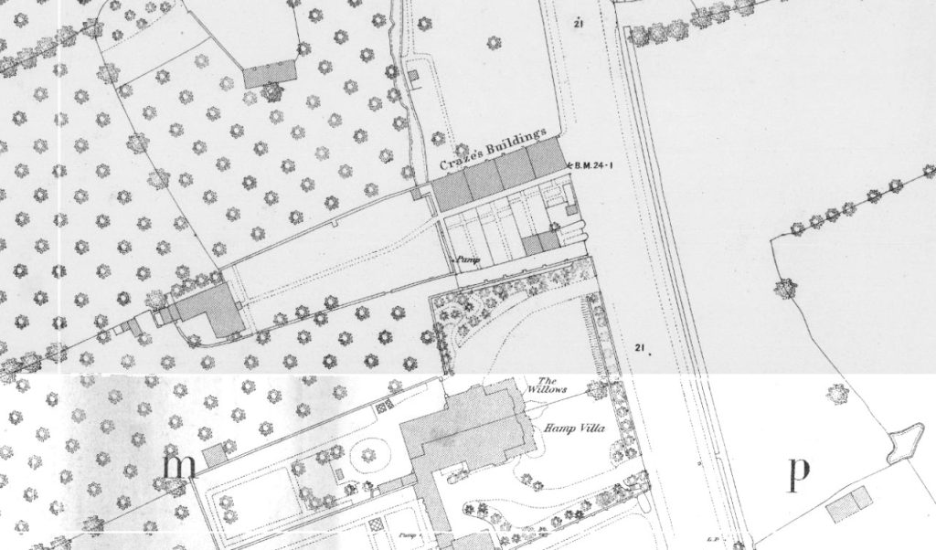
Craze’s Buildings: Now the entrance to Ashleigh Avenue. Presumably named after the builder/owner: John Craze 1775-1851 owned land at Hamp Southy by 1832 and by 1851 he was described as a ‘proprietor of houses’. He possibly lived in the large house that these buildings led up to (with thanks to Jill Tretheway) Seem to be shown on the 1840s Tithe Apportionment map. Shown on the c.1854 Town Plan and named on the 1889 OS Town Plan. Four cottages with garden plots, with a right of access pathway between cottages and gardens to a larger house and orchard behind – presumably Craze’s own house. They seem to survive the building of Ashleigh Avenue by 1904, although they lost their gardens for the construction. Replaced by a modern building by 2005. Spelled ‘Clazes’ and ‘Crazes’ Buildings in the 1891 census.
Crestfield Avenue: late: 20th century (1980s?) Chilton Street development. Unknown significance. All the streets on this development appear to have taken ‘c’ names. Built over a field called Escott’s Marshes (TAM)
Cridlands Meadow: Modern NDR development, complete by 2006. Name of unclear significance, possibly another name for the field it was built over, although it is recorded as ‘Four Acres’ on the Tithe Apportionment Map.
Cristata Way: Post 2006 Willstock Estate, date TBC. Named after a type of plant.
Cromwell Road: Built sometime between the 1930 OS map and the 1937 Whitby Directory. Presumably refers to Oliver Cromwell. Cromwell served under General Fairfax during the storm of Bridgwater in 1645, and both men were nearly drowned while crossing the Parrett at Dunwear, being hit by the Bore.
Cross Rifles: The junction of the Bath and Bristol Roads at Monmouth Street. Also known as The Cannon. Cross Rifles is the name of the adjoining pub from which the junction takes its name. The first recorded landlord was Elizabeth Davies in 1866 (Williams). This was not long after the formation of Bridgwater’s Rifle Volunteer Corps, which had a rifle range near Dunball. The pub was possibly a popular haunt after a day at the firing range. The third recorded publican, James Hurford (1822-1898), who managed the pub from before 1871, had previously served as a sergeant in the Royal Marines during the Crimean War. The Cannon refers to a Russian artillery piece, taken during the Crimean War which was kept here from 1889 to 1940, and a replacement can now be seen on the roundabout. Although Bristol Road dates to the early nineteenth century, this part of Monmouth Street was known as Keyling’s Cross. The name ‘Kelyng’, ‘Keling’ appears several times in medieval records associated with the town, the earliest in about the 1260s (Dilks no.7), so it is not a surprise to find a feature associated with someone of this family. Whether this was a trading cross, preaching cross or a roadside cross is unclear. Shown on the first Boundary Commission map of 1835. Called ‘Keelings toll gate’ on the second. The first mention of the cross (and possibly only mention, aside from nineteenth century boundary maps) comes from the borough charter of 1468, which has a perambulation of the town’s legal boundary – the Keyling Cross in the east, then south to Lyme Bridge, then across to Matthew’s Field, then north to Crowpill, then back to Keyling. These features were added to the 1830s boundary commissioners’ maps, although these may have retroactively added the medieval names from the charter to the known nineteenth century borough limits and made a best guess in marrying the two up.
Cross View Rise. Wembdon. Still fields on the 1948 RAF photographic survey. Modern development – date TBC. Built over a field called ‘the acre’ (TAM). The footpath from Church Lane appears on the 1904 OS Map, although not on the 1889 – only the old east west path at the top.
Crossacre. Wembdon. Built over ‘Cross Acre Orchard’, which appears on the 1840s Tithe Apportionment Map. Name of unclear significance, either the acre was the shape of a cross at some point (not by 1840) – possibly the site of a medieval cross? The north most houses on Church Lane were built by the 1946 RAF survey. The rest of the development is modern, built by 1972 (Town Guide, 1972)
Crossfield Close. Wembdon. Modern – date TBC. The name seems to take its lead from Crossacre.
Crowcombe Walk: Part of the cooperative housing estate built between the 1964 and the 1967 Town Guide plans. One of a series of street names on this estate to come from local villages. This is the ‘coombe’ ie valley settlement, frequented by crows.
Crowpill Lane: Crowpill Lane is something of a mystery, being within the site of Bridgwater Castle, and not actually leading to Crowpill. Crowpill itself is another mystery: the settlement is usually taken to be where the causeway over the Wembdon Levels from St George’s Church met Chilton Street. However, at the same time, Crowpill House was situated much to the south, behind Valetta Place. A ‘pill’ is derived from an Old Welsh word meaning creek, and in Somerset usually refers to the mouth of a stream into a larger river. So Crowpill is possibly the inlet frequented by crows. Exactly where this pill was though is hard to see now: it was where the Crowpill Rhyne met the river. There was another pill between Crowpill House and Valetta Place, which only confuses things.
Crusader Close: Modern NDR development, complete by 2006. Of of a group of names celebrating local carnival clubs: Crusaders Carnival Club.